AI-Based Drone Operation - AI in Drones use cases
Oct 16, 2023
Oct 20, 2026
Written by: Amirhossein Komeili
Reviewed by: Boshra Rajaei, PhD
Written by: Amirhossein Komeili
Reviewed by: Boshra Rajaei, PhD
According to Grand View Research, the global drone market size is projected to reach 163.60 billion by 2030. Traditional drone operations require constant human oversight, limiting their efficiency in time-sensitive missions and large-scale deployments. Manual piloting also increases operational costs and restricts coverage areas.
AI-powered drones are changing this landscape entirely. These intelligent systems can navigate autonomously, make real-time decisions, and adapt to dynamic environments without continuous human intervention. From precision agriculture to emergency response, AI transforms drones from remote-controlled devices into independent aerial platforms.
This article guides you on how AI enables drone autonomy, the technologies powering these systems, and their applications across industries. You'll learn about the benefits, challenges, and practical steps to implement AI-driven drone solutions using Saiwa's advanced platform.
Drones equipped with machine learning algorithms and computer vision capabilities that enable autonomous operation. Unlike traditional drones that follow pre-programmed flight paths or require manual control, these systems can perceive their environment, make decisions, and learn from experience.
The integration of AI allows drones to process sensor data in real time, identifying objects, avoiding obstacles, and adjusting flight patterns based on mission objectives. This autonomy significantly expands their utility beyond simple aerial photography to complex industrial applications requiring precision and adaptability.
AI drone systems operate through a coordinated process that combines hardware sensors with intelligent software algorithms:
This workflow enables drones to handle complex scenarios that would overwhelm manual operators, from tracking moving targets to inspecting infrastructure across vast areas.
AI-powered drones deliver measurable value across diverse sectors by automating tasks that are dangerous, time-consuming, or require extensive coverage:
AI-powered drones are changing the face of surveillance by autonomously detecting and responding to potential threats. They can monitor borders, large crowds and critical infrastructure in real time, identifying unusual patterns or movements without the need for constant human supervision.
In agriculture, AI-equipped drones use advanced computer vision and multispectral imaging to monitor crop health, detect diseases and pests at an early stage, and optimise the use of irrigation and fertiliser. This provides farmers with valuable insights to help them make data-driven decisions that improve yields, reduce waste and promote sustainable, regenerative farming practices.
AI-driven drones play a vital part in identifying and managing wildfires before they can spread out of control. Equipped with thermal sensors and AI pattern recognition technology, these drones can detect changes in temperature, smoke patterns and levels of vegetation stress. This data allows firefighters to identify high-risk areas, track the progression of fires in real time and coordinate containment efforts more safely and effectively.
AI lies at the heart of the next generation of delivery systems. Autonomous drones use machine learning algorithms and real-time environmental data to navigate complex urban environments, avoid hazards and maximise the efficiency of delivery routes.
Read Also: AI and Natural Disaster Prediction
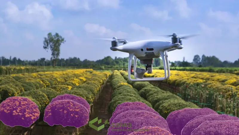
While traditional precision agriculture primarily focuses on immediate crop health and resource optimization, the latest AI drone applications are expanding rapidly into comprehensive ecological management. One of the most critical developments in this space is advanced UAV weed mapping combined with AI-driven invasive species prediction. This emerging frontier demonstrates how AI transforms drones from reactive observation tools into proactive environmental stewards.
By integrating multispectral imaging with cutting-edge computer vision models, drones are actively mapping complex ecosystems to identify invasive plant species before they can overwhelm native flora or compromise commercial agriculture. In these specialized operations, UAVs autonomously capture high-resolution spatial data across vast, often inaccessible terrains. Deep learning architectures then process this dense imagery in real time or via edge computing, distinguishing between native vegetation and invasive weeds with remarkable accuracy—often down to the individual plant or leaf level.
This transition from basic observation to proactive management relies heavily on the integration of predictive AI modeling. When artificial intelligence is applied to both historical and real-time UAV weed mapping data, the system can dynamically predict the future directional spread of invasive species. By correlating visual data with environmental variables such as terrain slope, soil moisture, and prevailing wind patterns, the AI creates highly accurate predictive threat maps. This intelligence enables land managers, conservationists, and agricultural professionals to achieve several critical objectives:
Targeted Interventions: Instead of relying on blanket chemical applications, managers can deploy highly localized, data-driven eradication efforts. This precision significantly reduces environmental toxicity, minimizes the chemical runoff into local water sources, and drastically lowers operational costs.
Forecasting Ecological Shifts: By anticipating exactly where invasive species are mathematically most likely to emerge next, organizations can implement preemptive containment strategies, stopping infestations before they require large-scale remediation.
Monitoring Long-Term Efficacy: Drones can use reinforcement learning and autonomous path planning to fly identical survey routes over consecutive seasons. This allows the AI to automatically track and quantify the long-term success rate of ongoing weed management programs without requiring constant human oversight.
The ability to seamlessly map, identify, and predict invasive threats perfectly illustrates the true potential of intelligent aerial systems. By leveraging advanced computer vision and predictive analytics, AI-powered drones empower users to move beyond simply recording their environment. Instead, they provide the actionable foresight required to manage complex ecological dynamics, ensuring more sustainable farming practices and resilient natural ecosystems.
Several core technologies enable intelligent drone operations:
Read Also : Leveraging Drones in Agriculture for Smarter Farming
The agricultural drone industry is rapidly transitioning from passive data collection to a "perception-decision-execution" closed-loop framework. Historically, UAVs required separate flights for mapping, offline cloud processing, and subsequent intervention. Today, lightweight edge devices and pruned neural networks allow drones to make microsecond decisions directly over the canopy. By addressing decision-making delays through onboard processing, these autonomous systems enable real-time targeted spraying and adaptive variable-rate chemical application without relying on continuous internet connectivity.
Running complex computer vision models on constrained drone hardware is a significant engineering challenge that has been solved by highly optimized architectures. For example, researchers have successfully deployed the Ag-YOLO object detection algorithm on extremely low-cost, low-power edge hardware like the Intel Neural Compute Stick 2. Operating at 1.5 watts, this setup achieves rapid processing speeds of 36.5 frames per second with a high degree of precision ( ). This synchronization of crop monitoring and variable-dosage spraying into a single, real-time process allows pesticides to be applied dynamically on a per-plant basis depending on the severity of the localized infection.
The integration of real-time edge computing is fundamentally altering traditional weed management and pest control strategies. Blanket chemical spraying not only damages surrounding ecosystems but also accelerates the evolution of herbicide-resistant weed species, presenting a critical threat to global food security. Advanced AI algorithms are currently being trained to accurately distinguish obscured weed species from cultivated crops within dense, actively growing canopies.
By pinpointing the exact coordinates of invasive plants, AI-equipped drones ensure that herbicides are only applied to affected zones rather than treating entire fields. This site-specific management minimizes the volume of synthetic chemicals leaching into the environment, drastically lowers the financial burden of agricultural inputs for farmers, and mitigates the rising threat of chemical resistance in both weeds and insect populations.
While AI drones offer impressive efficiency and coverage for large areas, they also face some downsides on the other hand.
Organizations adopting AI drone technology must address several considerations:
Data Requirements: Training accurate AI models demands extensive labeled datasets specific to each application, which can be time-consuming to collect and annotate.
Regulatory Compliance: Aviation authorities impose restrictions on autonomous flight, requiring organizations to navigate complex permitting processes before deployment.
Integration Complexity: Connecting drone systems with existing software platforms, databases, and workflows often requires custom development and IT expertise.
Initial Investment: High-quality AI-capable drones and supporting infrastructure represent significant upfront costs, though ROI typically materializes within 12-18 months.
Cybersecurity Risks: Connected drones face potential hacking threats, requiring robust encryption and access controls to protect sensitive data and prevent unauthorized access.
AI-powered drones deliver substantial operational improvements across metrics that matter to businesses:
Complete Area Coverage: Autonomous flight patterns ensure systematic inspection of large areas without gaps, achieving coverage rates impossible for manual operations.
Enhanced Accuracy: AI detection systems identify defects, anomalies, or objects with precision exceeding 95%, reducing false positives that waste inspection resources.
Cost Reduction: Automated operations eliminate the need for human pilots on routine missions, cutting labor costs by 50-70% while extending operational hours.
Real-Time Intelligence: Instant data processing provides actionable insights during flight, enabling immediate response to detected issues rather than waiting for post-mission analysis.
Safety Improvement: Drones eliminate human exposure to hazardous environments like toxic sites, high-voltage equipment, or unstable structures.
Implementing AI drone systems requires a structured approach that aligns technology with business objectives:
AI transforms drones from remotely piloted tools into intelligent systems capable of independent operation, complex analysis, and adaptive learning. The convergence of computer vision, deep learning, and edge computing enables applications that improve safety, reduce costs, and deliver insights impossible through traditional methods.
Developing AI systems for autonomous platforms, successful drone implementation depends less on acquiring the most advanced hardware and more on matching capabilities to specific operational needs. Organizations that start with clearly defined problems and incrementally expand their systems achieve better results than those pursuing technology for its own sake.
From our experience at Saiwa, real autonomy in drone systems requires more than object detection — it demands robust edge processing, adaptable AI models, and mission-specific learning pipelines. Our Sairone platform enables online/offline operation, continuous model improvement, and high-precision analysis of orthophotos and live UAV video streams, making AI-driven decisions reliable even in remote agricultural and environmental scenarios.
Note: Some visuals on this blog post were generated using AI tools.

As urban populations continue to grow globally, cities are grappling with various issues, from traffic congestion to deteriorating infrastru
Can AI create original art, write complex code, and make independent decisions? The rise of generative AI and agentic AI is reshaping techno

Contrast enhancement of poorly illuminated images have been widely used in many image processing applications where the subjective quality o

The field of archaeology, defined as the meticulous study of past human activity through the analysis of material remains, is undergoing a p

Artificial intelligence is driving new innovations across the entertainment industry, from assisting in content creation to personalizing me

The field of artificial intelligence (AI) is characterized by a dynamic evolution, with novel approaches and methodologies continuously emer
Be the first to share your thoughts
Start the conversation by sharing your thoughts
Share this article
Help others discover this content
Get expert insights, product news, and industry trends delivered straight to your inbox.
No spam, unsubscribe anytime. We respect your privacy.
