AI-Powered European Water Chestnut Detection Using UAV Imagery
Sep 22, 2026
Written by: Maryam Rajaei
Reviewed by: Boshra Rajaei, PhD
Sep 22, 2026
Written by: Maryam Rajaei
Reviewed by: Boshra Rajaei, PhD
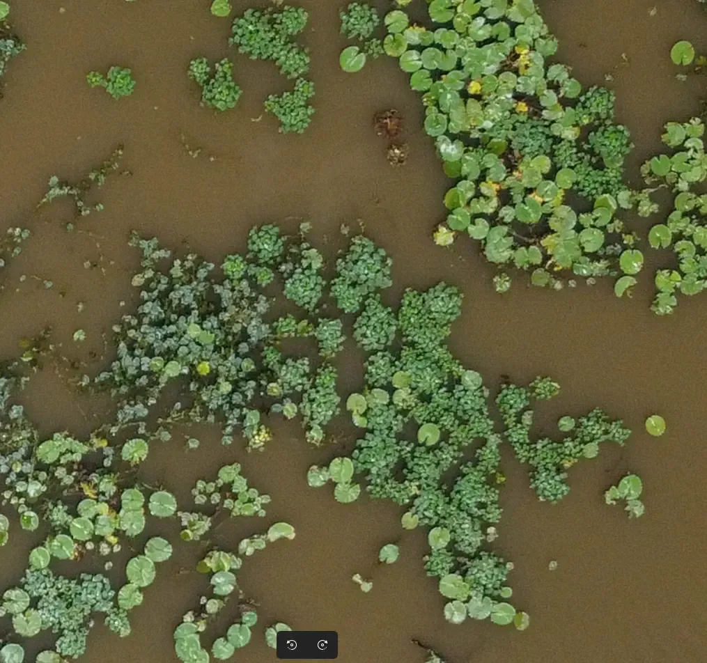
European Water Chestnut (EWC) is an invasive aquatic plant capable of rapidly covering lakes, ponds, and slow-moving waterways. Dense colonies restrict water flow, reduce biodiversity, and interfere with recreational and ecological activities. Effective management requires frequent monitoring of affected wetlands, but conventional field surveys are labor-intensive, time-consuming, and often impractical for large areas.
Advances in unmanned aerial vehicles (UAVs) and computer vision provide an efficient alternative for large-scale vegetation monitoring. High-resolution aerial imagery enables detailed observation of aquatic environments, while deep learning models can automatically identify invasive vegetation. However, detecting European Water Chestnut presents several challenges, including dense overlapping leaves, varying lighting conditions, water reflections, and the large size of orthophotos.
This project introduces an AI-powered semantic segmentation system designed to detect European Water Chestnut colonies from drone orthophotos. The segmentation solution was integrated by Sairone into for Ducks Unlimited Canada (DUC), combining a transformer-based segmentation model with an optimized processing pipeline and an interactive interface for reviewing and exporting detection results.
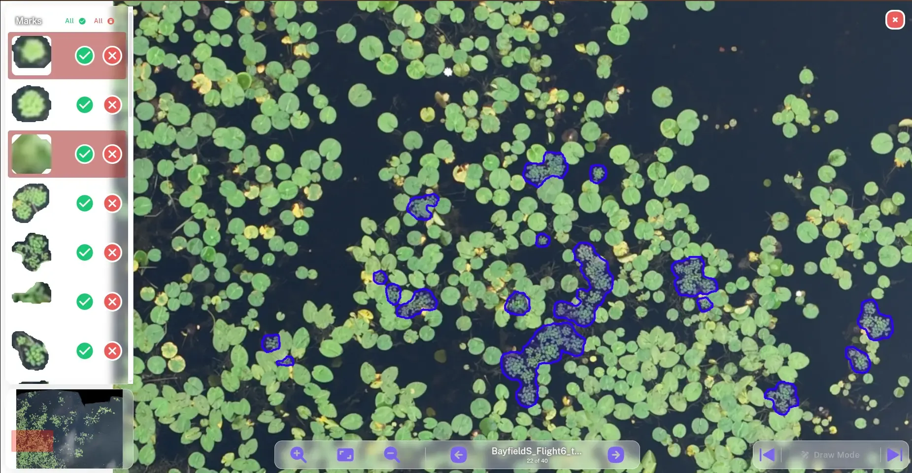
The objective of the project was to develop a complete workflow capable of transforming large aerial orthophotos into accurate segmentation maps of European Water Chestnut colonies.
The system performs the following tasks:
Processes high-resolution UAV orthophotos.
Detects European Water Chestnut colonies using semantic segmentation.
Converts segmentation masks into vector polygons.
Filters insignificant detections.
Provides an interactive interface for visualization and validation.
Exports GIS-compatible outputs for further environmental analysis.
The workflow was designed for practical deployment in environmental monitoring applications. Sairone integrated the segmentation algorithm enabling the complete process from orthophoto processing to visualization and export of the resulting vegetation maps.
The training dataset consisted of UAV orthophotos collected over wetland environments containing European Water Chestnut colonies. Since orthophotos are considerably larger than the input size supported by deep learning models, the images were divided into smaller tiles before training and inference.
Each tile was paired with manually annotated segmentation masks representing European Water Chestnut regions. Care was taken to maintain annotation consistency across different colony sizes and environmental conditions.
Data preprocessing included image normalization, tile generation, and quality verification to ensure reliable training samples.
Semantic segmentation was selected instead of object detection because European Water Chestnut typically forms dense, continuous colonies rather than isolated plants. Pixel-level segmentation allows accurate estimation of colony boundaries and surface coverage.
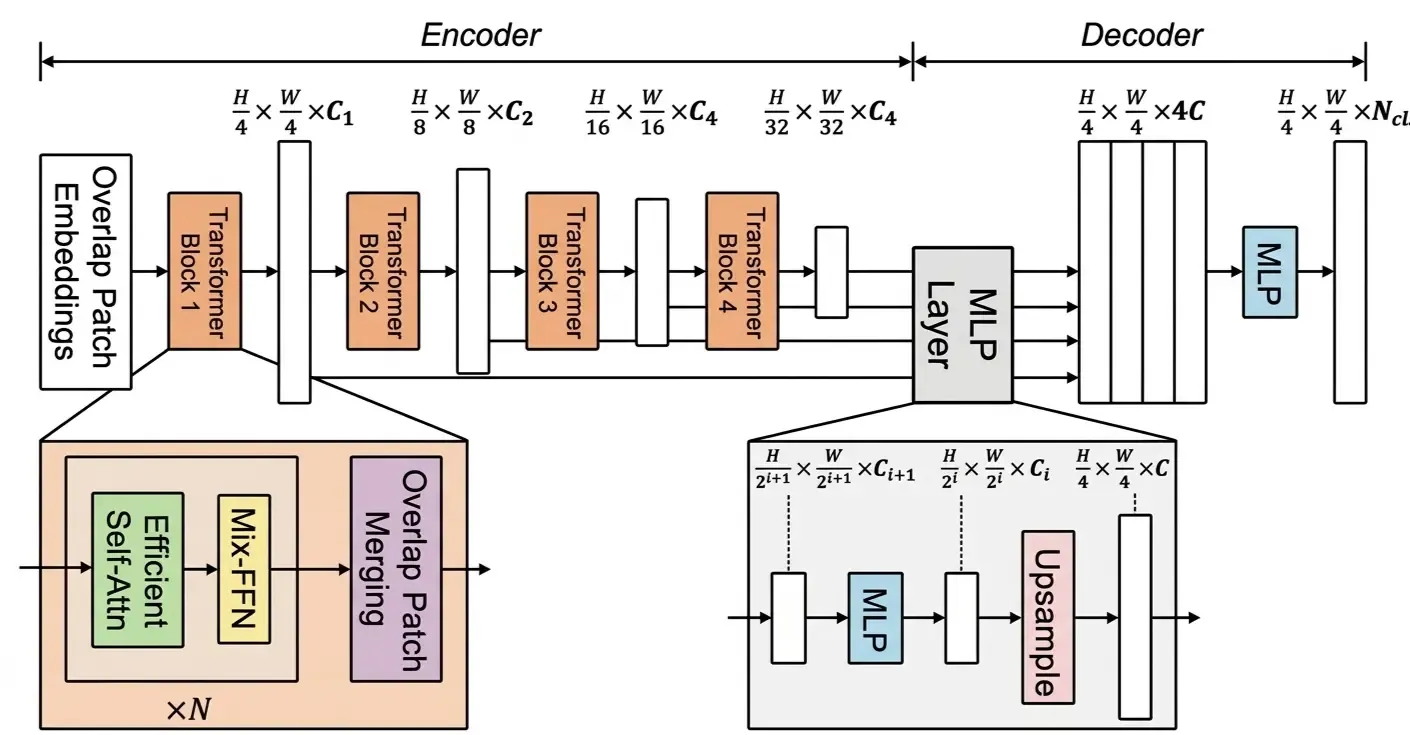
The segmentation model is a transformer-based network designed for efficient semantic segmentation. Compared with conventional convolutional neural networks, transformer architectures capture broader contextual information while maintaining competitive computational efficiency.
The semantic segmentation model provides several advantages for this application:
Accurate segmentation of irregular vegetation boundaries.
Robust performance under varying illumination.
Efficient processing of high-resolution imagery.
Good balance between accuracy and inference speed.
Model training was performed using the MMSegmentation framework. The training pipeline included dataset preparation, image augmentation, optimization, and validation.
Several preprocessing and augmentation techniques were applied to improve model generalization under varying environmental conditions, including differences in lighting, vegetation density, and image orientation.
Throughout training, model performance was monitored using segmentation metrics to ensure stable convergence and minimize overfitting.
Inference begins by dividing a large orthophoto into manageable image tiles.
Each tile is processed independently by the segmentation model, producing a probability map indicating the likelihood that each pixel belongs to a European Water Chestnut colony.
The resulting predictions are combined to reconstruct the segmentation of the complete orthophoto. Post-processing techniques are then applied to improve the quality of the final output by removing small artifacts and converting raster masks into clean vector polygons.
This tiled inference strategy enables processing of very large orthophotos without exceeding GPU memory limitations.
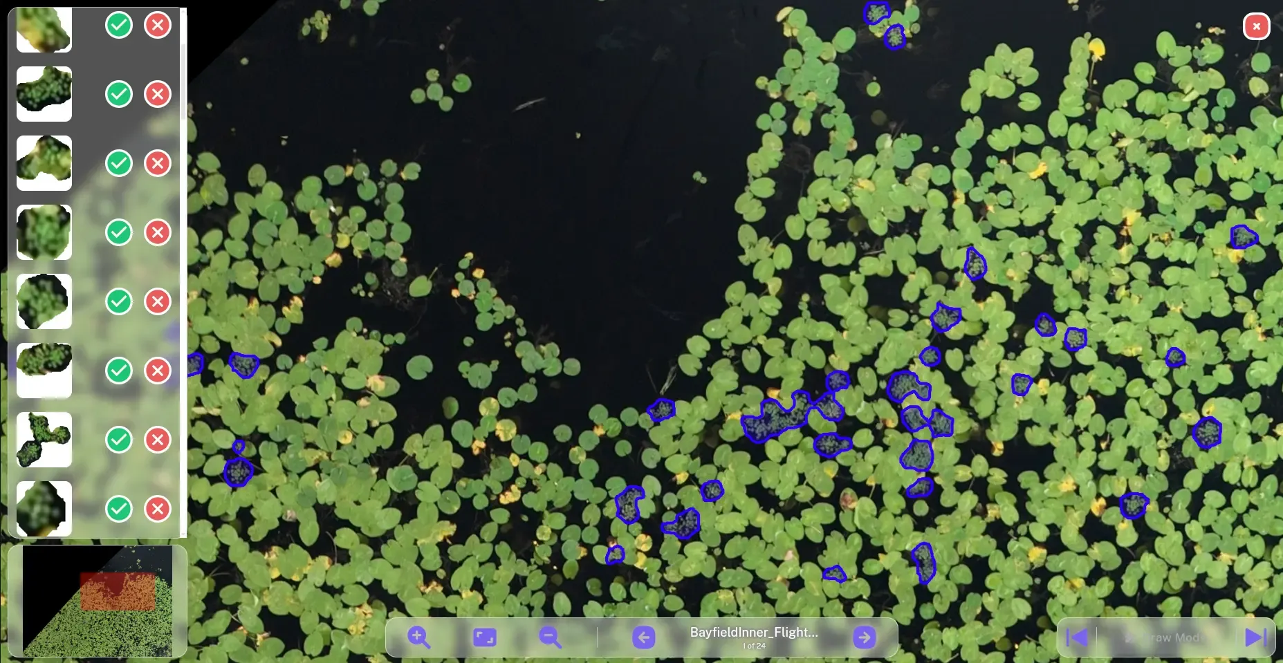
Raw segmentation masks are not directly suitable for GIS analysis. Therefore, several post-processing steps are performed.
Connected vegetation regions are converted into polygons representing colony boundaries. Small isolated regions can be filtered using configurable size thresholds, reducing false detections caused by image noise.
The generated polygons can then be exported for integration with geographic information systems and environmental management workflows.
Sairone integrated the segmentation algorithm into its software platform, providing an interactive environment for processing UAV orthophotos, reviewing segmentation results, and exporting GIS-compatible outputs.
The platform enables users to:
Select different segmentation model versions.
Configure detection parameters.
Process orthophotos automatically.
Visualize segmentation overlays.
Review predicted polygons.
Export results in GIS-compatible formats.
The integration separates the underlying segmentation model from the user-facing processing workflow, allowing the model to be applied to large orthophotos while providing tools for reviewing and refining the resulting detections.
The developed segmentation system was integrated by Sairone into its software platform and applied to UAV orthophotos for detecting European Water Chestnut colonies for Ducks Unlimited Canada. The combination of transformer-based semantic segmentation, efficient tiled inference, and automated polygon generation provides a practical workflow for large-scale monitoring of invasive aquatic vegetation.
Beyond the segmentation model itself, the integration into a software platform streamlines the complete process—from orthophoto input to GIS-ready outputs—reducing manual effort and improving the consistency of vegetation mapping.
This project demonstrates how modern semantic segmentation techniques can support environmental monitoring through automated analysis of UAV imagery. By combining deep learning, efficient image processing, and software integration, the solution provides a practical approach for identifying and mapping European Water Chestnut colonies at scale. The integration performed by Sairone also provides a foundation for extending the workflow to additional invasive plant species, imagery sources, and advanced geospatial analysis.
[1] Sairone EWC detector service: https://duc.saiwa.ca/
[2] Jian Cheng , Changjian Deng, Yanzhou Su, Zeyu An, Qi Wang. Methods and datasets on semantic segmentation for Unmanned Aerial Vehicle remote sensing images: A review. ISPRS Journal of Photogrammetry and Remote Sensing, 211, 1–34, 2024.
DOI: 10.1016/j.isprsjprs.2024.03.012
[3] Yuan, X., Shi, J., & Gu, L. A review of deep learning methods for semantic segmentation of remote sensing imagery. Expert Systems with Applications, 169, 114417, 2021.
DOI: 10.1016/j.eswa.2020.114417