DJI Drone Capabilities for AI-Powered Applications
Oct 15, 2026
Written by: Maryam Rajaei
Reviewed by: Boshra Rajaei, PhD
Oct 15, 2026
Written by: Maryam Rajaei
Reviewed by: Boshra Rajaei, PhD
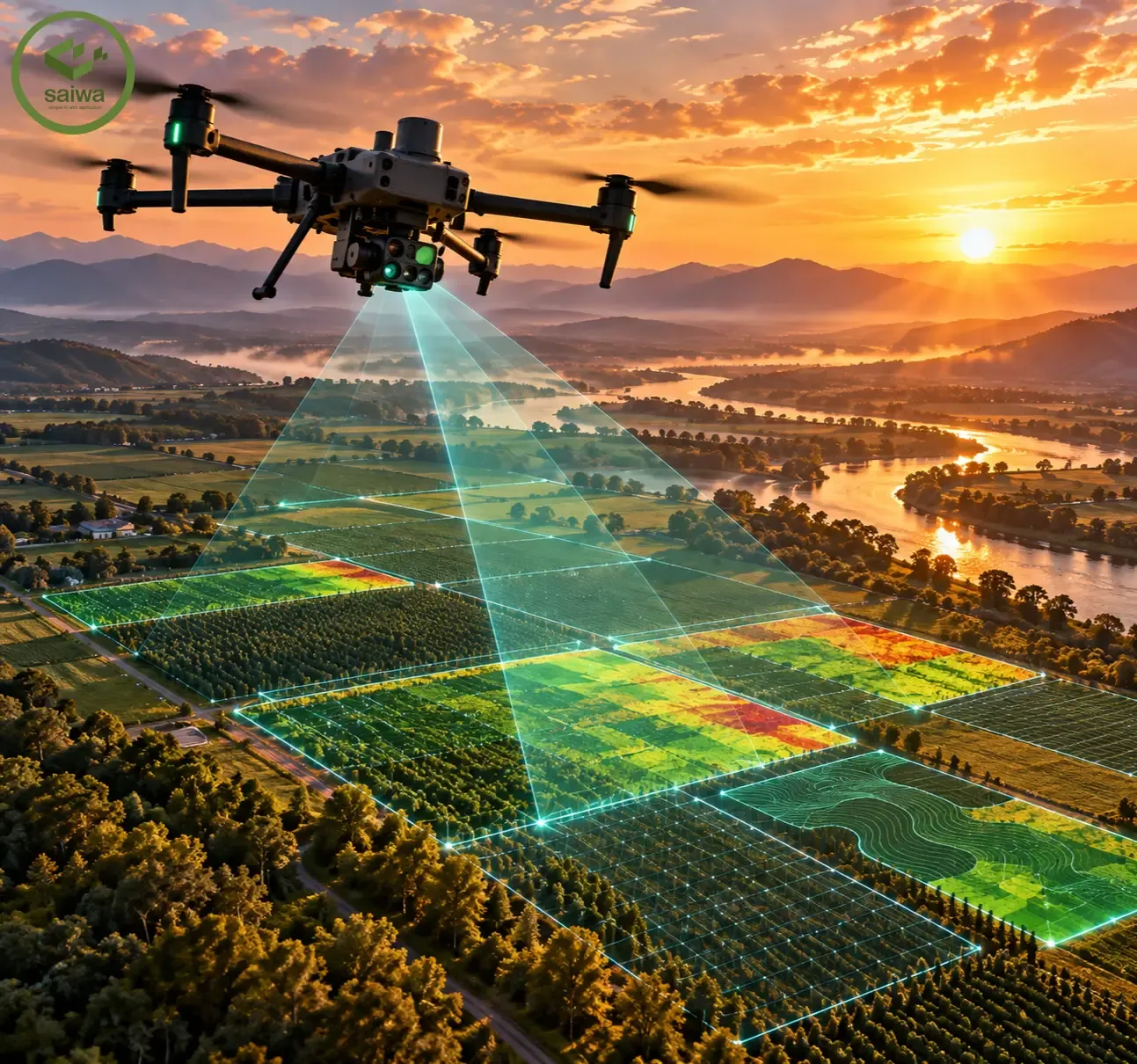
Unmanned Aerial Vehicles (UAVs) are widely used in agriculture, environmental monitoring, surveying, and industrial inspection. Modern DJI drones combine imaging sensors, automated flight control, precise positioning, and software development capabilities.
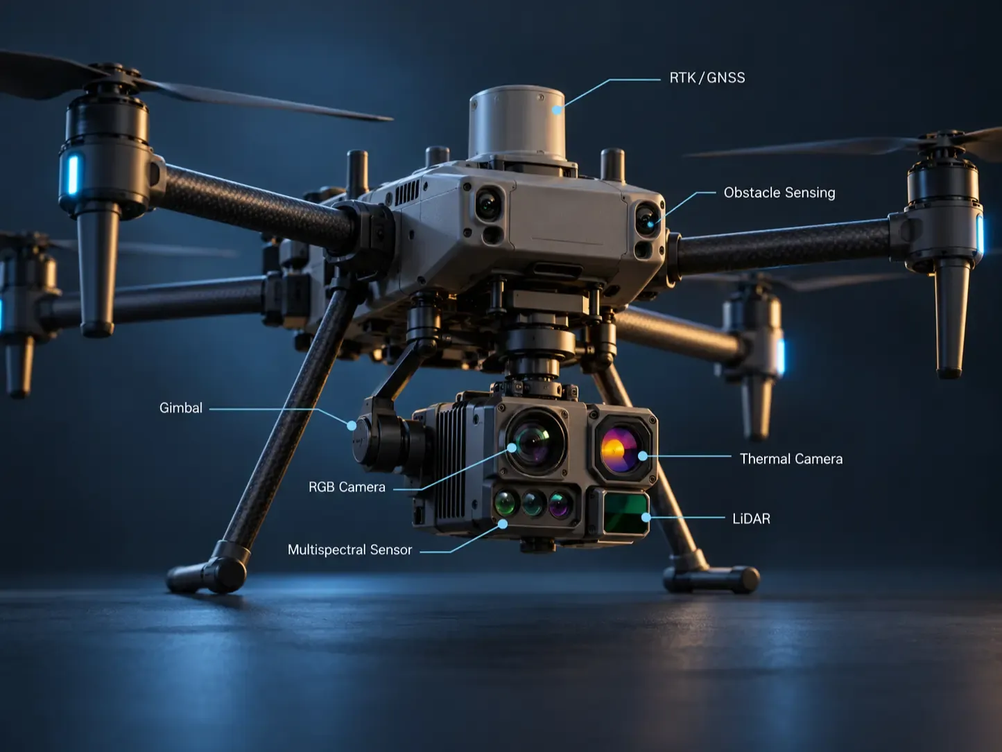
Depending on the model, DJI drones support RGB, thermal, and multi-spectral imaging, LiDAR sensing, autonomous missions, real-time data transmission, and third-party software integration.
An important advantage of DJI's ecosystem is the ability to combine these capabilities with artificial intelligence, computer vision, and custom software applications.
At Saiwa, we develop drone imagery-based applications for agricultural analysis through our Sairone platform. We are also developing custom SDKs and software integrations to leverage DJI's programmable flight capabilities, sensor data access, and AI functionalities, enabling more intelligent and automated agricultural workflows.
This report explores DJI's main technical capabilities, programming interfaces, AI integration, and agricultural applications.
DJI provides several imaging technologies for different operational requirements.
RGB cameras capture high-resolution aerial photographs and videos for mapping, inspection, and computer vision applications.
The DJI Matrice 4E includes a 20 MP wide-angle camera with a mechanical shutter, designed for surveying and mapping. The Matrice 4T combines RGB cameras with a 640 × 512 thermal sensor.
Other thermal-enabled models include the Mavic 3T, Matrice 30T, and Matrice 4TD.
Compatible drones can acquire RGB and thermal information during the same flight, supporting applications that require both visual and temperature-related observations.
The DJI Mavic 3 Multispectral (Mavic 3M) combines RGB imaging with four multispectral bands: green, red, red-edge, and near-infrared. These capabilities support vegetation monitoring and agricultural analysis.
DJI also provides LiDAR payloads, including the Zenmuse L-series, for 3D point cloud acquisition, terrain modeling, and geospatial mapping.
Imaging capabilities vary by aircraft and payload configuration.
DJI drones support automated flight operations on compatible platforms.
Waypoint missions allow aircraft to follow predefined routes and perform actions at selected geographical positions.
Depending on the model and available software interfaces, functions include:
Automated waypoint navigation and mission execution.
Configurable altitude, speed, and flight parameters.
Automated image capture during flight.
RTK positioning for improved geographical accuracy.
Obstacle sensing and avoidance using compatible sensors.
Real-time flight status and telemetry monitoring.
Selected enterprise platforms provide additional sensing capabilities. For example, the Matrice 400 integrates LiDAR, radar, and vision-based technologies for obstacle detection.
These functions support repeatable data acquisition and automated surveying workflows.
DJI provides both built-in intelligent functions and development interfaces for integrating custom AI algorithms.
Selected DJI platforms include onboard intelligent detection and tracking capabilities.
For example, the Matrice 4 Series incorporates an AI computing platform with detection functions for selected object categories, including:
People
Vehicles
Vessels
DJI also documents intelligent tracking functions and support for additional AI models on compatible configurations.
These features provide predefined AI functionality without requiring developers to build every detection component independently.
However, built-in AI capabilities differ between models. A detection feature available on the Matrice 4 Series should not be assumed to exist on other DJI aircraft.
Beyond built-in intelligent functions, DJI provides software interfaces that enable third-party developers to integrate their own computer vision and machine learning algorithms.
Depending on the aircraft and development environment, these integrations can support:
Processing live video streams using external AI models.
Object detection and image segmentation.
Real-time visual analysis on connected computing devices.
AI-assisted image acquisition and monitoring.
Processing drone imagery in cloud-based applications.
For example, a custom computer vision application can analyze video frames from a supported DJI camera and use its results to determine when additional image acquisition is required.
This type of application uses DJI's available data and control interfaces together with externally developed AI algorithms.
Important distinction: DJI's SDKs provide access to supported aircraft functions and data. They do not automatically provide trained AI models for custom tasks such as crop detection or weed segmentation.
DJI provides several Software Development Kits (SDKs) and APIs that enable developers to build customized applications and integrate drone systems with external software.
These programming interfaces are particularly important for AI-powered drone applications, where image acquisition, flight control, and data processing must work together.
DJI Mobile SDK enables developers to create applications for controlling and monitoring compatible aircraft.
Depending on the supported model and SDK version, available functions include:
Camera Control: Capture images, record videos, configure camera settings, and control the gimbal.
Real-Time Video: Access supported camera video streams for live processing.
Flight Control: Execute supported flight commands and use Virtual Stick control.
Mission Automation: Configure and execute waypoint missions.
Telemetry Access: Retrieve flight status, positioning, and supported sensor information.
Media Management: Access, preview, and download captured images and videos.
These capabilities allow developers to create applications that combine aircraft operations with external AI processing.
For example, an application can continuously analyze a camera stream using a vegetation detection algorithm and request an image capture when defined conditions are met.
The actual implementation depends on camera stream availability, supported control APIs, and aircraft compatibility.
DJI Payload SDK allows compatible third-party hardware and computing devices to communicate with supported aircraft.
It provides interfaces for payload integration, data communication, and selected aircraft functions.
PSDK can support applications involving custom sensors, onboard computing hardware, and specialized processing systems.
Some capabilities require specific hardware, such as compatible expansion modules or DJI Manifold computing devices.
DJI Onboard SDK provides programmatic access to flight control and telemetry on supported aircraft through connected onboard computers.
This enables developers to implement specialized software functions that operate independently of a conventional mobile application.
OSDK compatibility is limited to supported platforms and should be checked separately from Mobile SDK and Payload SDK support.
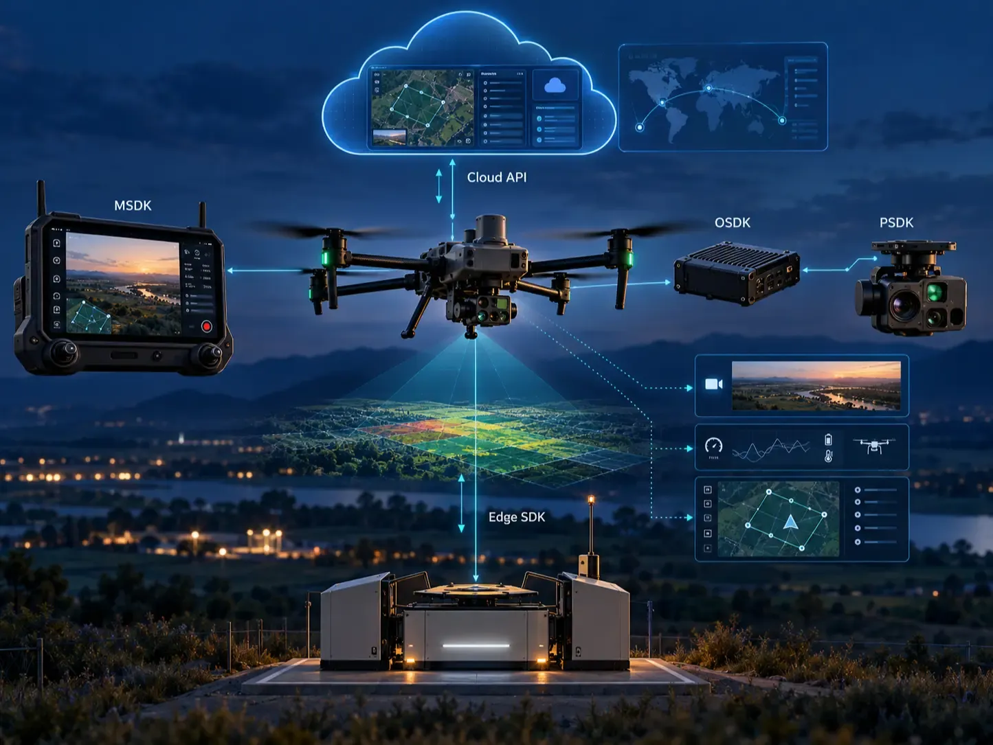
DJI Cloud API enables supported aircraft and dock systems to communicate with third-party cloud platforms.
Its interfaces support functions including device management, mission-related operations, data exchange, and video integration.
DJI Edge SDK provides local data-processing capabilities for compatible dock environments.
Together, these technologies offer different approaches to integrating AI applications:
Mobile processing: Running computer vision algorithms on video received through an application.
Onboard processing: Executing algorithms on compatible computing hardware connected to the aircraft.
Edge processing: Analyzing data near supported drone docking infrastructure.
Cloud processing: Sending supported drone data to external services for AI inference and further analysis.
The appropriate architecture depends on the aircraft, connectivity, processing requirements, and supported SDK functions.
DJI's imaging and development capabilities provide opportunities for AI-powered agricultural applications.
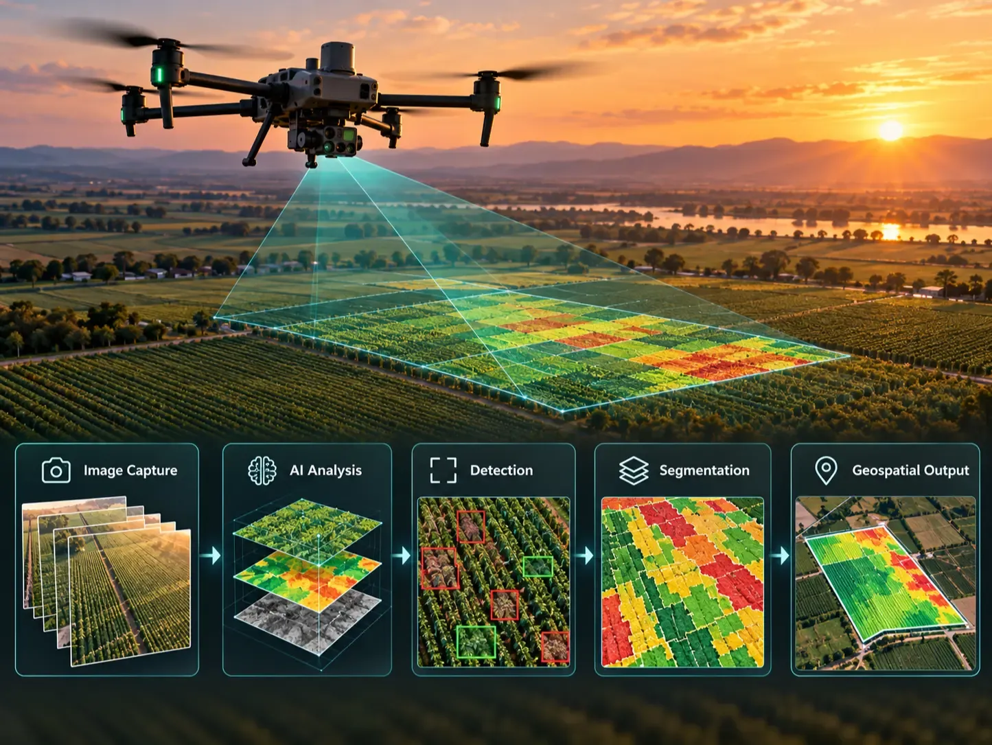
High-resolution RGB images can be processed using object detection and semantic segmentation models to identify plants, weeds, and agricultural features.
Multispectral imagery provides additional spectral information for vegetation analysis, while thermal sensors provide temperature-related observations.
Automated flight missions and positioning systems support systematic image collection and geospatial analysis.
Potential applications include:
Weed and invasive plant detection.
Crop health and vegetation monitoring.
Plant counting and crop stand assessment.
Agricultural field mapping.
AI-assisted aerial image acquisition.
Automated analysis of georeferenced drone imagery.
By integrating drone data with machine learning models, raw aerial imagery can be transformed into detection results, segmentation maps, and geospatial outputs.
At Saiwa, we are using DJI drone technologies and exploring their programming capabilities to enhance Sairone, our AI-powered agricultural platform.
Sairone focuses on applying artificial intelligence and computer vision to agricultural monitoring and analysis.
DJI's SDK ecosystem creates further opportunities to integrate AI algorithms directly into drone-based workflows.
Our development efforts focus on capabilities such as:
AI-Based Image Analysis: Applying custom detection and segmentation models to drone imagery.
Intelligent Image Acquisition: Using computer vision results to support conditional image capture.
Flight Automation: Integrating programmable flight and camera controls into agricultural workflows.
Data Integration: Connecting drone image acquisition with AI inference and geospatial processing.
Combining DJI's supported interfaces with Sairone's AI capabilities can help connect aerial data acquisition, automated processing, and agricultural decision-making.
Although DJI provides extensive hardware and software capabilities, not every function is available on every aircraft.
Several factors determine whether a particular integration is possible:
Aircraft and camera hardware specifications.
SDK compatibility with the selected DJI model.
Firmware version and supported API functions.
Availability of real-time video and sensor data.
Requirements for onboard computing or additional payloads.
Restrictions affecting automated flight and obstacle sensing.
For AI applications, it is especially important to verify whether the required camera data and flight-control functions are accessible through the selected SDK.
The DJI Payload SDK documentation provides additional information about hardware-specific development interfaces.
DJI offers a broad range of capabilities for aerial imaging, automated flight, intelligent sensing, and software integration.
While certain models provide built-in AI functions, DJI's SDK ecosystem also enables developers to build customized applications using external machine learning and computer vision algorithms.
Mobile SDK, Payload SDK, Onboard SDK, Cloud API, and Edge SDK provide different integration approaches, from application-level flight control to onboard and cloud-based data processing.
At Saiwa, these capabilities support the continued development of Sairone as an AI-powered agricultural platform. By combining DJI drone technologies with our custom AI models, we aim to improve aerial data acquisition, automate agricultural analysis, and provide more actionable information for precision agriculture.