



RGB vs. Multispectral Cameras for AI-Based Weed Mapping
Learn why sensor selection matters for AI weed mapping and how RGB and multispectral imaging improve crop-weed detection.
Written by Amirhossein
Reviewed by Boshra
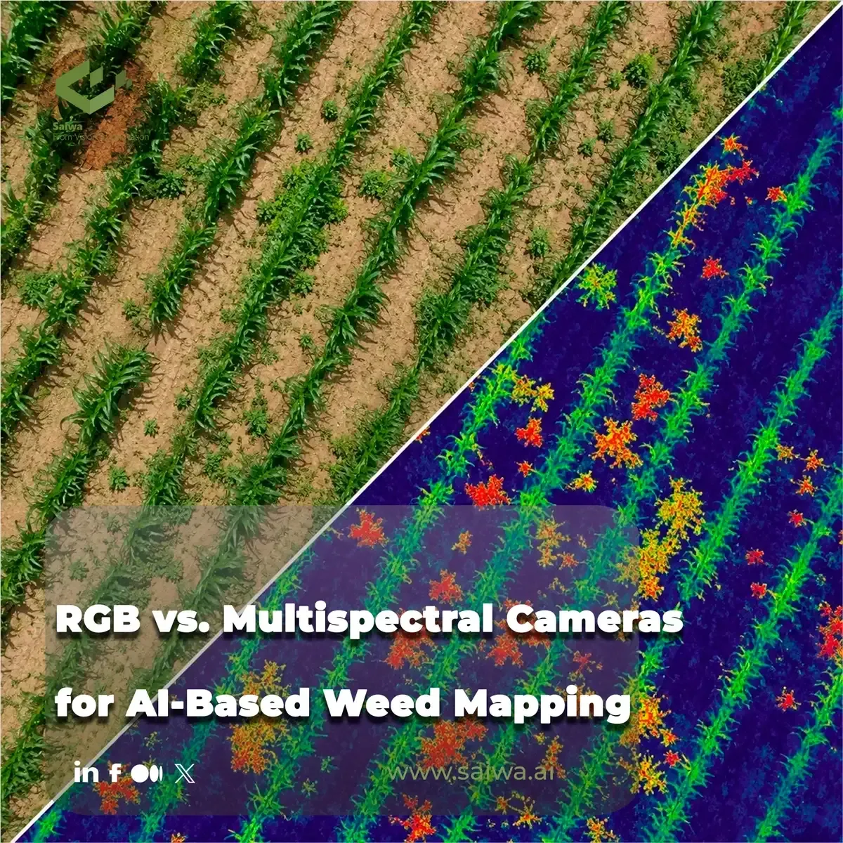
Why Sensor Selection Matters for AI-Based Weed Mapping
Implementing automated weed detection pipelines requires a rigorous assessment of hardware before software can even be deployed. The optical sensor mounted on an unmanned aerial vehicle (UAV) or terrestrial machine dictates the quality, dimensionality, and utility of the data fed into downstream neural networks. Selecting the correct imaging payload directly determines whether an algorithm can successfully distinguish unwanted vegetation from cash crops or if it will fail due to data ambiguity.
Modern precision agriculture relies heavily on spatial data to execute targeted interventions, reducing chemical inputs and optimizing yield. The fundamental divergence in sensor technology for these applications lies between standard optical (RGB) and multispectral systems. Each camera type imposes distinct operational constraints, data processing requirements, and limits on algorithmic performance, forcing agronomists and machine learning engineers to align hardware capabilities with specific field objectives.
Mechanical Weed Control, Herbicide Reduction, and Spot-Spraying Objectives
The primary goal of a weed mapping campaign governs the technical specifications required from the sensor. Broad-spectrum weed detection — identifying general areas of weed pressure across a field — often requires less spectral depth than species-specific classification. If a management strategy simply requires identifying vegetation outside the main crop rows, standard visible-spectrum imagery can provide sufficient contrast for computer vision models to isolate these anomalies.
Conversely, identifying specific weed species growing intra-row (within the crop rows) demands a higher degree of feature extraction. Crops and weeds often exhibit nearly identical visual characteristics to the human eye and standard cameras during early phenological stages. When the objective shifts from simple presence/absence mapping to precise botanical classification, the sensor must capture variations in plant health, chlorophyll content, and cellular structure that are invisible in standard color imagery.
RGB Imaging for UAV Weed Mapping
RGB cameras represent the most accessible and widely deployed sensor modality in remote sensing for agriculture. Operating strictly within the visible light spectrum (capturing red, green, and blue wavelengths), these sensors mimic human vision. Because they are manufactured at massive scale for consumer and industrial applications, RGB payloads offer high spatial resolution at a relatively low hardware cost.
For machine learning applications, RGB imagery provides a familiar data structure (standard three-channel matrices) that integrates seamlessly with established computer vision architectures like convolutional neural networks (CNNs). This accessibility allows for rapid model prototyping and deployment without specialized radiometric calibration steps.
Relative Color Indices and Affordability Advantages
Standard RGB sensors excel at capturing morphological features such as leaf shape, texture, and plant architecture. High-resolution visible imagery allows AI models to distinguish broadleaf weeds from grasses based purely on geometry and spatial patterns. Furthermore, researchers have developed numerous visible-spectrum vegetation indices, such as the Excess Green Index (ExG), which mathematically emphasizes the green channels to separate vegetation from bare soil or residue.
The primary advantage of RGB systems remains their cost-to-resolution ratio. Operators can mount high-megapixel RGB cameras on lightweight, affordable UAVs, capturing vast areas of farmland with minimal capital expenditure. The resulting datasets yield incredibly sharp orthomosaics, enabling human operators to visually verify AI detections and providing clear baselines for field navigation.
Sensitivity to Lighting, Shadowing, Canopy Overlay, and Similar Visual Signatures
Despite their ubiquity, RGB sensors suffer from significant limitations in complex agronomic environments. These cameras are highly susceptible to variations in ambient lighting; a passing cloud or a change in the sun's angle can drastically alter the pixel values of the target plants. This illumination variance confuses AI models trained on specific lighting conditions, leading to false positives and reduced accuracy during early morning or late afternoon flights.
Additionally, shadows cast by taller crop canopies obscure smaller understory weeds, effectively hiding them from RGB sensors. The most critical failure point of RGB imagery occurs when the crop and the weed share the same shade of green. When plants are phenotypically similar, visible-spectrum data lacks the depth required to separate the pixels, forcing the AI to rely entirely on shape — a metric that fails when plants are overlapping or wind-blown.

Multispectral Imaging for Crop-Weed Discrimination
Multispectral cameras bypass the limitations of human vision by capturing data across multiple, discrete wavelength bands, extending beyond the visible spectrum. By isolating specific segments of the electromagnetic spectrum, these sensors record fundamental physiological differences between plant species.
The integration of multispectral hardware introduces a higher level of complexity into the data acquisition process. These cameras require precise radiometric calibration using reflectance panels before and after flights to ensure that the recorded pixel values represent true surface reflectance, irrespective of sunlight intensity.
Additional Spectral Bands, NIR Integration, and NDVI-Based Separation
The defining characteristic of a multispectral sensor is its ability to capture Near-Infrared (NIR) and Red Edge wavelengths. Healthy vegetation reflects NIR light intensely due to the spongy mesophyll structure within the leaves. Because different plant species possess unique cellular structures and varying levels of chlorophyll, their reflectance signatures in the NIR and Red Edge bands differ significantly, even when they appear identically green to an RGB camera.
By manipulating these specific bands, agronomists generate advanced vegetation indices, most notably the Normalized Difference Vegetation Index (NDVI). AI models ingest these multispectral indices alongside the raw band data to differentiate crops from weeds based on internal plant physiology rather than just external morphology. This spectral separation allows for highly accurate intra-row weed detection, where physical shapes are otherwise indistinguishable.
Resolution, Flying Altitude, and Affected-Spot Identification
While multispectral cameras offer superior spectral depth, they historically compromise on spatial resolution compared to their RGB counterparts. A multispectral sensor typically possesses a lower megapixel count per band, resulting in a higher (less detailed) Ground Sampling Distance (GSD) at a given flight altitude.
To achieve the millimeter-level GSD required to identify small, newly emerged weeds, UAV operators must fly multispectral payloads at much lower altitudes than they would RGB cameras. This reduction in flight height drastically increases the time required to survey a field and generates a larger volume of individual images, which complicates the photogrammetry and stitching processes. Balancing the need for spectral richness against the requirement for sharp spatial delineation remains a primary engineering challenge in survey planning.
AI Workflows for Weed Detection Models
The raw imagery captured by UAVs holds no inherent agronomic value until it is processed through advanced machine learning algorithms. AI workflows transform massive arrays of pixel data into actionable spatial intelligence. The architecture of these models must be carefully tuned to the specific type of sensor data being ingested.
Developing an effective AI pipeline requires vast amounts of annotated training data. Engineers must manually label thousands of images, drawing bounding boxes or creating pixel-perfect masks around target weed species, to teach the neural networks how to identify patterns.
Instance Segmentation Datasets, Transfer Learning, and Mask-RCNN Evaluation
Object detection models, such as those based on the YOLO (You Only Look Once) architecture, are frequently deployed for weed mapping. These algorithms analyze the image matrices and output bounding boxes identifying the location and class of specific plants. For more granular analysis, semantic segmentation networks classify every individual pixel in the image as either "crop," "weed," or "background," providing precise area measurements of weed infestations.
Training these models on multispectral data requires modifying standard neural network architectures, which are typically designed for three-channel RGB inputs, to accept five or more channels simultaneously. This multi-channel ingestion allows the AI to weigh spectral signatures (like NIR reflectance) heavily in its decision-making matrix, improving classification accuracy in complex environments.
Scenario-Based Performance Differences Between RGB and Multispectral Data
The performance delta between RGB-trained models and multispectral-trained models fluctuates based on the field scenario. In fields with distinct morphological differences between crops and weeds (e.g., broadleaf weeds in cereal crops), RGB models often achieve accuracy rates exceeding 90%, making them highly efficient for specific applications.
However, when addressing intra-row weeds of a similar botanical family to the crop, RGB model accuracy drops sharply. Under these conditions, AI models trained on multispectral data maintain high performance metrics. The inclusion of NIR data allows the model to ignore overlapping shadows and focus on the distinct spectral responses of the differing species, ensuring reliable detection across varied growth stages.
From Imagery to Prescription Maps
The output of an AI weed detection model is merely an intermediate step in the precision agriculture pipeline. To provide value, the raw detections must be converted into standardized, georeferenced formats that farm machinery and agronomic software can interpret.
This transformation bridges the gap between remote sensing analytics and physical field intervention. By converting pixel coordinates into global geographic coordinates, software platforms create actionable maps that dictate where chemical or mechanical treatments should be applied.
QGIS and Georeferenced Outputs for Targeted Applications
Once the AI identifies weed locations within the high-resolution orthomosaics, the software generates geospatial vector data. These outputs allow farm managers to visualize weed pressure across hundreds of hectares, identifying hot spots and analyzing spatial distribution patterns.
Integrating this data into standard Geographic Information Systems (GIS) enables agronomists to overlay the weed maps with other spatial datasets, such as soil types, topography, and historical yield maps. This multi-layered analysis facilitates a deeper understanding of why weeds are aggregating in specific field zones, informing long-term management strategies.
Spot Identification for Nozzle Control and Localized Herbicide Use
The ultimate objective of AI-based weed mapping is the creation of prescription files for variable-rate technology (VRT) and smart sprayers. Instead of broadcasting herbicides uniformly across an entire field, the mapping software translates the AI detections into precise spatial commands.
These commands direct smart sprayer systems to activate individual nozzles only when passing directly over an identified weed cluster. This localized, targeted application dramatically reduces herbicide volume, mitigating chemical runoff, lowering input costs, and protecting the surrounding environment while maintaining crop yield.
Sairone and its Field Application in AI-Driven Precision Agriculture
Scaling Remote Sensing Data through Cloud Intelligence
Sairone operates as an advanced, AI-driven platform engineered by Saiwa to resolve the computational bottlenecks associated with precision agriculture. The platform is designed to seamlessly ingest high-resolution imagery captured from a variety of sources, including aerial drones, satellite constellations, and machine-mounted cameras. By leveraging robust cloud architecture, Sairone processes complex multi-sensor geospatial data without relying on local hardware constraints. A defining capability of the platform is its capacity to handle massive cloud uploads of "mega files," such as high-density TIFF orthomosaics. Sairone ingests these massive datasets at full resolution, executing deep learning analyses without requiring local data reduction or downsampling, preserving the critical spatial integrity required for micro-level plant detection.
Automated Species Identification and Density Mapping
Within its comprehensive suite of agricultural tools, Sairone's "Weed and Invasive Plant Control" service provides specialized botanical intelligence. The platform deploys advanced computer vision algorithms trained to move beyond simple vegetation indices, executing highly accurate species identification. The AI models are specifically calibrated to detect and classify problematic species such as Taraxacum officinale (dandelion), Amaranthus albus (tumble pigweed), fleabane, and various thistle varieties. By isolating these specific invasive plants against complex crop backgrounds, Sairone generates exact spatial density maps. These maps quantify the severity of the infestation per square meter, providing agronomists with granular data regarding species distribution and localized competitive pressure.
Translating Spatial Insights into Variable-Rate Field Action
Sairone bridges the gap between analytical intelligence and mechanical intervention by outputting highly structured, GIS-based visualization layers. The platform generates standardized formats including Shapefiles, GeoJSON, CSV, and KML, ensuring immediate compatibility with modern tractor terminals and smart sprayers. To optimize field logistics, Sairone utilizes an advanced auto-clustering algorithm. This system automatically analyzes the spatial distribution of detected weeds and groups the affected field sections into clean, optimized management blocks. This automated clustering process occurs within hours of data upload, saving agronomists significant planning time and generating highly efficient routing for variable-rate chemical applications.
Custom AI Infrastructure and Enterprise B2B Customization
Recognizing that agricultural operations vary wildly across different geographies and crop types, Sairone avoids rigid, one-size-fits-all software templates. The platform offers deep enterprise integration by providing customized plant detection models trained specifically on a client's unique regional imagery and target species. Beyond customized AI, Sairone provides tailored reporting dashboards that align directly with specific agronomic metrics. For large-scale agricultural enterprises and service providers, Saiwa offers full white label options and Back-end as a Service (BaaS) APIs. This architecture allows organizations to seamlessly integrate Sairone's powerful weed detection pipelines directly into their existing proprietary software ecosystems, aligning the AI infrastructure directly with their operational and commercial goals.
References (6)
Comments
No comments yet!
Table of Contents
No headings were found on this page.