



AI Weed Detection to Reduce Herbicide Resistance Pressure
Learn how AI weed detection, deep learning, precision spraying, robotics, and spatial mapping can reduce unnecessary herbicide exposure
Written by Amirhossein
Reviewed by Boshra
Herbicide resistance becomes a larger operational challenge when weed populations are repeatedly exposed to the same herbicide modes of action, while broadcast spraying can increase unnecessary chemical use by treating areas where weeds are absent. AI weed detection offers a more spatially precise alternative: identify crop and weed plants, map infestations, distinguish relevant species, and direct treatment toward confirmed targets. This approach does not eliminate resistance by itself, but it can reduce unnecessary herbicide exposure and support more deliberate, site-specific management decisions.
This article examines the relationship between herbicide resistance pressure and broadcast spraying, the deep-learning methods used to detect weeds, and the integration of machine vision with precision sprayers and agricultural robots. It also explains why human validation, local agronomic knowledge, legal label compliance, and field-level performance assessment remain essential. The final section describes how Sairone turns aerial and georeferenced imagery into weed detections, spatial treatment zones, and enterprise-ready data services.
The Rise of Herbicide Resistant Weeds
Drivers of Weed Resistance in Agriculture
Herbicides transformed agricultural weed control by reducing dependence on hand labor and supporting efficient management over large production areas. Their repeated use, however, has imposed sustained selection pressure on weed populations. By 2021, 521 unique cases of herbicide resistance had been documented worldwide, involving 164 herbicides and 23 of the 26 known herbicide sites of action. The development pipeline has not necessarily kept pace: only four new herbicides were introduced between 2010 and 2014, according to the historical assessment cited by Oregon State University.
Resistance becomes especially difficult to manage when a production system depends heavily on a limited number of herbicide mechanisms. Glyphosate-resistant cropping systems illustrate the problem. Glyphosate-tolerant soybean entered the market in 1996, followed by glyphosate-tolerant corn in 1997; by 2014, 29 weed species had developed glyphosate resistance. Multiple resistance adds another layer of difficulty because changing to a different or stronger herbicide after a control failure can continue the cycle rather than resolve the underlying selection problem.
AI does not alter weed biology or replace integrated weed management. Its practical value lies in improving the information available before treatment. When detection systems determine which plants are present and where infestations occur, managers can move away from undifferentiated chemical exposure and toward interventions tailored to field conditions.
Limitations of Broadcast Herbicide Application
Uniform spraying treats the field as though weed pressure were spatially constant. In reality, infestations are often uneven. Applying the same herbicide rate across infested and weed-free areas exposes non-target surfaces, increases chemical residues, and contributes to environmental pollution without adding control value in locations where weeds are absent.
Site-specific weed management uses weed coverage information to guide the selection and spatial distribution of treatment. Prescription maps can provide decision data to variable-rate systems mounted on tractors or UAVs, allowing application to reflect mapped weed conditions. Real-time machine-vision systems take a different route: cameras and onboard processing detect vegetation during field operation and adjust application through a spray controller.
Reducing sprayed area should not be confused with automatically solving resistance. A precisely applied but agronomically unsuitable herbicide can still fail. AI-generated recommendations can also be inaccurate, inconsistent with product labels, or poorly adapted to local weed populations. Cornell weed scientists therefore emphasize professional agronomic review and pesticide-label compliance before any application.
Deep Learning Models for Weed Identification
Advancements in Image Recognition Algorithms
Earlier machine-vision systems often relied on manually designed color indices, texture descriptors, spectral characteristics, or morphological rules. These techniques can perform well in controlled settings, but field variation creates persistent difficulties. Illumination changes, soil backgrounds, crop-leaf occlusion, variable weed morphology, and differences among crop growth stages can all weaken models built around fixed, hand-engineered features.
Deep learning shifts feature extraction into the training process. Convolutional neural networks and Transformer-based architectures learn multi-scale spatial and semantic representations directly from images. In weed-management applications, classification networks assign plant or image classes, object detectors locate weeds with bounding boxes, and segmentation models delineate vegetation at pixel level. The appropriate model depends on whether the operational requirement is species recognition, plant counting, mechanical targeting, coverage estimation, or prescription-map generation.
Fully convolutional networks are particularly relevant to aerial weed mapping because they perform end-to-end, pixel-to-pixel classification. A UAV study in rice used this approach to convert high-resolution imagery into field-scale weed-cover and prescription maps. The workflow addressed a limitation of object-based image analysis, which depends on manually selected features that can be application-specific and difficult to generalize.

Differentiating Crop and Weed Phenotypes
Crop–weed differentiation is difficult because both targets are plants, often share similar colors, and may overlap within the same image. Their appearance also changes with growth stage, weather, illumination, camera position, and field background. Deep models can learn discriminative patterns across these variables, but their reliability remains tied to the relevance and coverage of the training data.
The consequences of incomplete training data are operational rather than theoretical. Cornell reported poor control of common ragweed during early work with two AI-guided machines in New York because the species was uncommon in the western United States and was not represented adequately in their training algorithms. A system may therefore perform well on familiar species and still miss a locally important phenotype.
Model evaluation should consequently extend beyond a single aggregate accuracy score. Agronomic teams need to examine false negatives, which leave weeds untreated; false positives, which trigger unnecessary interventions; species-level performance; and behavior across locations and growth stages. Human review is especially important when model output contributes to pesticide selection, because correct visual identification does not by itself establish that a particular product or use pattern is legal, safe, or agronomically appropriate.
Precision Spraying and Robotics Integration
Real-Time Targeted Application Systems
A machine-vision variable-rate herbicide system links sensing, image analysis, decision logic, and nozzle control. One published row-crop implementation combined a grayscale imaging unit, a data-processing unit, and a multi-nozzle variable-rate controller. The camera was mounted on a tractor ahead of the spraying assembly, creating time for image processing before the corresponding section of ground reached the nozzles.
Application rate can be altered through pressure adjustment or pulse-width modulation. Both methods introduce engineering constraints. Changing pressure can affect atomization at a fixed nozzle tip and provides a limited range of flow adjustment. Low-frequency pulse-width modulation, although effective, can produce discontinuous spraying. Accurate perception is therefore only one part of system performance; actuation quality, processing speed, communication capacity, vehicle speed, and nozzle response also determine whether a detection becomes a correct field treatment.
Prescription-map systems separate observation from application. UAV imagery can first be converted into a weed-cover map, which then supplies decision information for a tractor- or UAV-based variable-rate sprayer. This approach offers broad spatial context, while real-time sensing responds to conditions visible during the application pass. The choice between them depends on operational timing, required resolution, available hardware, and the acceptable delay between imaging and treatment.
Autonomous Agricultural Robotics Platforms
Agricultural robots apply the same perception principle to chemical and non-chemical control: identify the crop and weeds selectively, act on the intended target, and minimize disturbance to the crop. Available concepts include vision-guided spraying, mechanical removal, flaming, and laser-based treatment. These platforms can reduce dependence on broad chemical application, but they still require reliable classification under changing field conditions.
Deep-learning weed perception can run across multiple sensing platforms, including UAVs, ground robots, autonomous tractors, and intelligent implements. Lightweight classification or detection networks may be needed where inference must occur on embedded hardware with tight latency and memory limits. By contrast, cloud or workstation processing can support larger aerial datasets and field-level mapping when immediate actuation is unnecessary.
Autonomy does not remove the need for supervision. A robot can consistently execute an incorrect classification or treatment decision at machine speed. Deployment should therefore include field validation, monitoring of missed and falsely detected plants, assessment of crop injury, and procedures for stopping or overriding the system when performance leaves its validated operating range.
Developing Custom Weed Management Strategies
Data-Driven Herbicide Selection
A useful weed-management plan begins with identification and spatial distribution, then combines that evidence with agronomic judgment. Precision-agriculture tools can distinguish weed types and divide fields into management zones, helping operators replace repeated trial-and-error treatments with more targeted decisions. Spatial data can also reveal whether an infestation is isolated, dispersed, or concentrated in recurring patches.
Species identification alone is not a herbicide recommendation. Product choice depends on the crop, weed species, growth stage, location, environmental conditions, application timing, resistance status, and the legally approved label. Even time of application can influence efficacy; the reviewed Taranis material reports that glyphosate can be less effective when applied before 10:00 a.m. or after 4:00 p.m..
AI-generated treatment guidance must remain subordinate to registered labels and trained professional review. Cornell documented examples in which general-purpose AI tools suggested herbicides that were not legally registered for the target crop, creating risks of regulatory violations and severe crop injury. Detection systems are most defensible when they deliver verified observations and decision-support layers rather than presenting unreviewed chemical instructions as autonomous prescriptions.
Evaluating Efficacy and System Constraints
Field evaluation should measure the entire chain from image acquisition to weed control. Relevant checkpoints include image quality, geolocation, crop–weed classification, species recognition, treatment-zone construction, command transfer, nozzle or robotic actuation, weed suppression, and crop safety. A failure at any stage can reduce efficacy even when the underlying neural network performs well.
Data conditions deserve particular attention. UAV mosaics can be extremely large; one rice study produced orthomosaics of approximately (14{,}000 \times 13{,}000) pixels and divided them into (1{,}000 \times 1{,}000)-pixel patches to preserve spatial resolution while operating within CPU and GPU memory limits. High-resolution mapping therefore involves practical trade-offs among ground resolution, coverage, processing time, storage, and deployable computing resources.
Evaluation should also test transferability. Models trained in one region may encounter unseen species, growth forms, soils, or production practices elsewhere. Human-in-the-loop correction, local retraining, and repeated field validation can help identify these gaps. The operational objective is not simply a convincing image overlay; it is a repeatable system that converts reliable observations into lawful, agronomically sound action.
Sairone and its Field Application in AI-Driven Precision Agriculture
Scaling Remote Sensing Data Through Cloud Intelligence
Sairone is Saiwa’s AI-based B2B SaaS platform for agricultural service providers, agronomists, cooperatives, researchers, and environmental specialists. Its computer-vision workflow accepts images, videos, and orthomosaics and produces analytical outputs for applications that include weed and invasive-plant control. Customers can use the hosted cloud platform without developing and maintaining an equivalent processing infrastructure internally.
For weed analysis, Sairone supports high-resolution drone captures, precision orthophotos, georeferenced data, and batch uploads in TIFF, GeoTIFF, JPEG, and PNG formats. Its cloud file environment stores raw drone imagery, input datasets, and processed results, including large-file uploads for high-volume datasets. GeoTIFF metadata and coordinate reference information are retained for subsequent geospatial analysis.
The platform also provides tagging and annotation tools for preparing and correcting datasets. These capabilities support object identification and counting while giving project teams a mechanism for adapting data and models to the target use case.
Automated Species Identification and Density Mapping
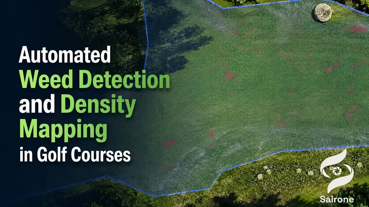
Sairone’s Weed and Invasive Plant Control service uses computer vision and machine learning to detect, map, and analyze weeds in agricultural fields and natural environments. The platform returns confidence information and geographic coordinates for detections, then transfers validated records into its Atlas environment for visualization and spatial analysis.
The documented species set includes dandelion (Taraxacum), waterhemp (Amaranthus tuberculatus), Palmer amaranth (Amaranthus palmeri), European water chestnut, water soldier, fleabane, and thistle. This species-specific approach matters because a generic vegetation mask cannot provide the same level of information for monitoring a known resistant or difficult-to-control weed.
Sairone incorporates a human-in-the-loop validation stage in which users can review, correct, and approve AI detections. Confirmed results can then be used to examine infestation patterns and construct treatment maps. This review layer helps prevent raw model output from moving directly into management without expert inspection.
Translating Spatial Insights into Variable-Rate Field Action
Within Atlas, users can view weed distribution over aerial and satellite basemaps, define regions, organize zones hierarchically, and examine geospatial dashboards. Detection-clustering algorithms group confirmed weeds into manageable treatment zones, converting scattered point observations into operational blocks for precision spraying.
Sairone exports GIS-ready data as GeoJSON, Shapefile, KML, and CSV. These formats allow validated detections and treatment zones to move into external GIS and downstream precision-application workflows. The documented capability supports precision spraying and targeted treatment planning; the final compatibility and rate-control behavior depend on the receiving equipment and its software configuration.
Clustering also reduces the need to translate individual detections manually into field sections. Agronomists can begin with structured zones, inspect them against the underlying imagery, and refine the management plan before export. This preserves professional oversight while shortening the route from image analysis to spatially explicit action.
Custom AI Infrastructure and Enterprise B2B Customization
Sairone does not use a single fixed template for every agricultural problem. Saiwa develops or customizes specialized AI models according to the customer’s data, target objects, and operational requirements. This model allows weed-detection services to reflect the plant species and imagery relevant to a specific organization rather than relying exclusively on a generic classifier.
Delivery options include the hosted Sairone platform, integration through customized APIs, and a fully customized white-label platform aligned with the client’s brand and workflow. Its multi-tenant architecture and Back-end as a Service model are intended for agritech businesses that need to embed analytical functions into an existing service or customer-facing product.
Tailored reporting, annotation, model development, API access, and white-label deployment make the platform suitable for enterprise workflows in which data acquisition, agronomic review, GIS analysis, and client reporting must operate as one coordinated process. The central value is controlled customization: the detection model and delivery layer can be aligned with an organization’s defined operational goals.
Conclusion
AI weed detection can reduce herbicide resistance pressure by improving where, when, and against which weeds control measures are deployed. Deep-learning detection, segmentation, UAV mapping, real-time machine vision, and robotic actuation can replace indiscriminate field-wide treatment with spatially selective management. Their contribution is strongest when they reduce treatment of weed-free areas, expose infestation patterns, and support differentiated responses to specific weed populations.
These systems remain decision-support and execution technologies, not substitutes for resistance management, agronomic expertise, or pesticide regulation. Reliable deployment requires representative training data, local validation, human review, equipment testing, and strict compliance with product labels. Platforms such as Sairone can organize the imaging, detection, validation, clustering, and GIS-export stages, but agronomists must still determine whether the resulting field action is effective, lawful, and appropriate for the production system.
Comments
No comments yet!
Table of Contents
No headings were found on this page.