Semantic Segmentation for Detecting Phragmites australis in Remote Sensing Imagery
Apr 15, 2026
Written by: Maryam Rajaei
Apr 15, 2026
Written by: Maryam Rajaei
Phragmites australis, commonly known as the common reed, has become one of the most problematic invasive species in wetland ecosystems around the world. While native forms of the plant can play a useful ecological role, invasive strains tend to spread aggressively, forming dense stands that crowd out local vegetation, reduce biodiversity, and alter both water flow and habitat conditions.
What makes Phragmites australis particularly challenging to manage is its ability to propagate in multiple ways. It spreads not only through seeds but also via extensive underground rhizome systems, allowing it to expand quickly and re-establish even after partial removal. Because of this, early detection is not simply beneficial, it is essential. Catching infestations at an early stage makes targeted intervention possible, keeps management costs under control, and helps prevent broader ecological disruption.
In practice, however, identifying these early-stage invasions is difficult. Traditional field surveys require significant time, labor, and access to often hard-to-reach wetland areas. As a result, they do not scale well for large regions. This limitation has driven growing interest in remote sensing and AI-based analysis as more efficient and scalable alternatives.
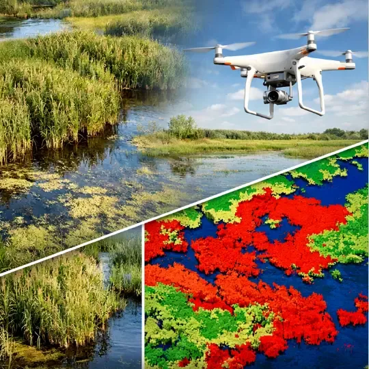
At Saiwa, this challenge is addressed through a dedicated pipeline designed for detecting Phragmites australis in high-resolution aerial imagery acquired via UAV platforms. The input data consists of RGB orthorectified TIFF images, which provide dense spatial information and consistent ground sampling distance, enabling fine-grained analysis over large wetland ecosystems.
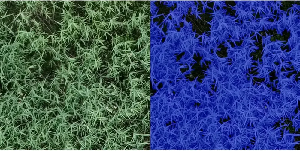
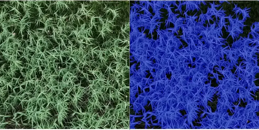
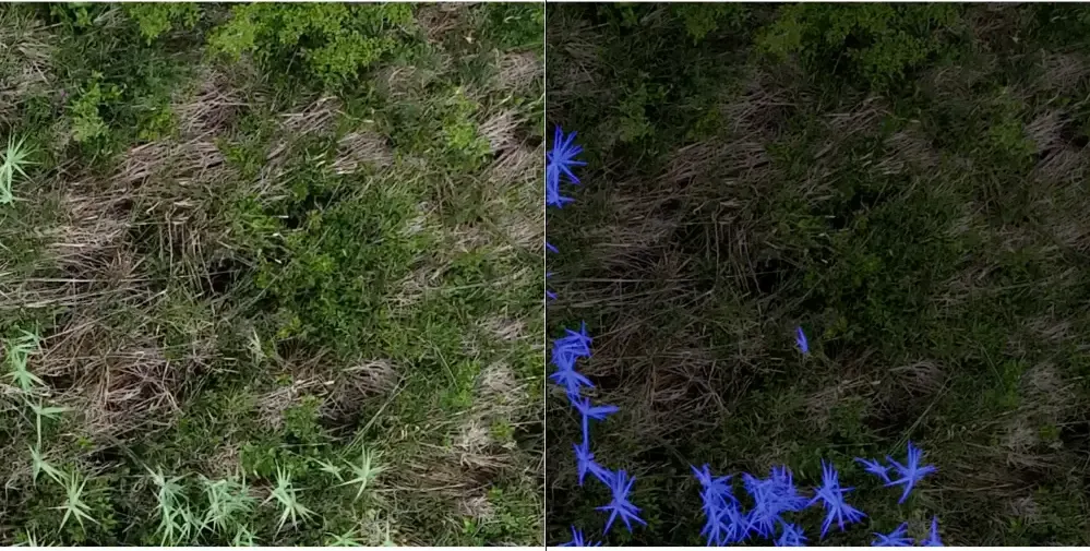
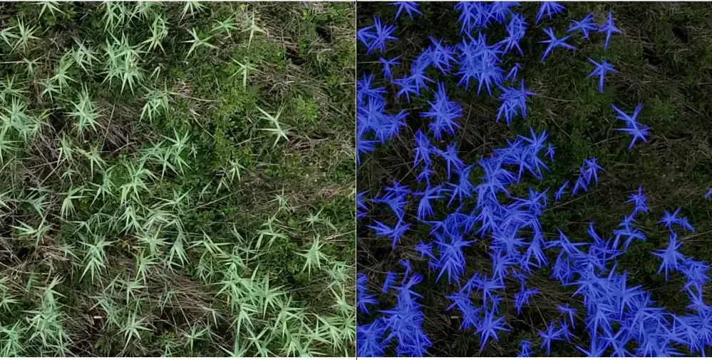
At the core of the system lies a semantic segmentation framework that formulates the detection task as a dense, pixel-wise classification problem. Instead of predicting discrete object instances, the model assigns a class label to every pixel in the image, effectively partitioning the scene into meaningful regions. Formally, given an input RGB image I∈RH×W×3, the goal is to learn a mapping:
where fθ represents the parameterized model and Y is a binary mask indicating the presence (1), or absence (0), of Phragmites australis at each pixel location. This formulation allows the system to capture subtle spatial patterns and heterogeneous textures that are characteristic of invasive vegetation, particularly in environments where class boundaries are diffuse or intermixed with native species.
A practical issue with UAV imagery is its very large size, which often exceeds the memory limits of standard processing pipelines. To handle this, each image is first split into smaller, fixed-size tiles before annotation for training and inference. Each tile is processed independently, and the outputs are later stitched back together to reconstruct the full-resolution segmentation map. This tiling approach keeps the computation manageable while still preserving fine spatial details that are important for accurate boundary delineation.
The system’s output goes beyond a simple visual overlay, it provides data that can be directly used in decision-making. By accurately segmenting areas affected by Phragmites, users can get a clear picture of how extensive the invasion is, track how it evolves over time, and identify which locations require immediate attention.
This level of insight makes it easier to prioritize intervention efforts and allocate resources more effectively, whether the goal is removal, containment, or ongoing monitoring. In that sense, the system turns raw UAV imagery into a practical decision-support tool for environmental teams, conservation groups, and land managers working in the field.
One of the strengths of Saiwa’s approach lies in how it balances technical capability with practical usability. Although the system is built on advanced computer vision methods, it is designed to fit naturally into real-world workflows. Users can process large collections of RGB TIFF imagery without needing expertise in machine learning.
At the same time, the system is designed to handle the variability that comes with real environments. Differences in lighting, seasonal changes, and landscape complexity are all part of the data it encounters. Rather than relying on ideal conditions, the pipeline is built to remain consistent across these variations, supported by robust model behavior and data handling strategies.
The global spread of Phragmites australis continues to pose a significant ecological and economic challenge. Managing it effectively depends on being able to detect and track its presence at scale, something traditional methods often struggle to achieve in practice.
By combining UAV-based data collection with segmentation-driven analysis, Saiwa offers a more practical way to identify and monitor invasive reed populations. This shifts the process from reactive management toward a more proactive approach, where earlier detection supports faster response, more informed planning, and ultimately, more sustainable ecosystem management.