Stand Count in Agriculture: Precision Agriculture in Action
Stand Count is the foundation of precision farming—track plant emergence, estimate yield early, and optimize inputs with manual or AI-powered drone analysis.
Written by Amirhossein
Reviewed by Boshra
An accurate assessment of plant population during the early stages of growth determines the outcome of the entire growing season. However, traditional manual counting methods only provide limited snapshots of vast fields through small sample areas, which are then applied to hundreds or thousands of acres. Methods such as walking measured row lengths or using hula hoops to define random sample zones capture data from perhaps only small percentage of the total field area.
Using AI to count stands addresses these limitations by analyzing high-resolution drone imagery of entire fields. Computer vision algorithms distinguish individual seedlings from soil and weeds with over 99% accuracy and generate comprehensive population maps. These maps reveal emergence patterns, gaps and uniformity issues that are invisible to sample-based methods.
This in-depth guide explores stand counting technologies, examining manual methods and providing historical context, as well as AI-powered aerial approaches that are revolutionizing population assessment. It also covers implementation strategies.

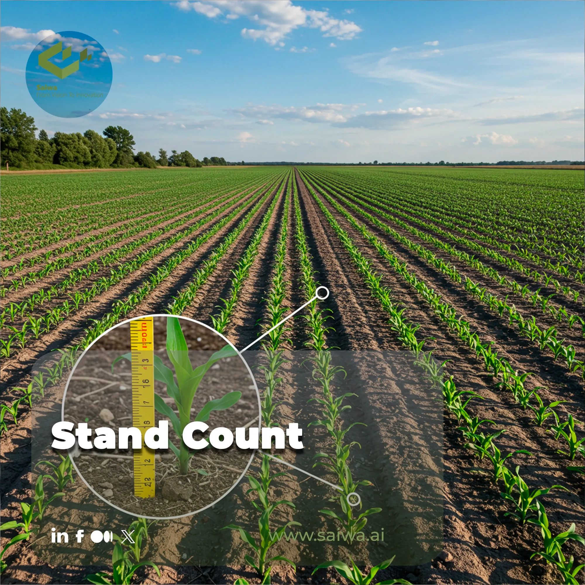
What Is Stand Count and Why Is It Critical?
Stand count is a way of measuring how many seedlings have emerged and how dense the plant population is. It establishes precise baseline measurements of actual plant populations against target seeding rates.
This metric is crucial because plant population directly affects yield potential. Poor stands reduce photosynthetic capacity and productivity, while overly dense populations increase competition for light, water and nutrients without proportional yield increases.
How Stand Counting Works
Stand counting integrates data collection and analysis processes delivering comprehensive plant population assessments:
- Manual Field Survey Methods: Traditional approaches involve walking measured row lengths counting plants within distances representing fractions of acres, typically 1/1000th acre samples at multiple field locations. The hula-hoop method defines random circular sample areas particularly effective for broadcast-seeded crops like soybeans lacking distinct rows.
- Aerial Imagery Acquisition: Drones equipped with high-resolution RGB cameras fly systematic patterns over fields at 30-100 meter altitudes capturing overlapping images providing complete coverage. Precision GPS systems including Real-Time Kinematic positioning ensure sub-centimeter georeferencing accuracy enabling reliable seedling identification and mapping.
- AI-Powered Image Analysis: Computer vision algorithms trained on thousands of annotated agricultural images analyze captured imagery distinguishing individual seedlings from soil backgrounds and weed vegetation. Deep learning models including Convolutional Neural Networks and object detection frameworks like YOLO or Mask R-CNN identify plant locations with exceptional accuracy even in visually complex scenarios with overlapping leaves or variable lighting.
- Population Mapping and Reporting: Analysis results generate georeferenced plant location maps revealing spatial patterns in emergence including consistent gaps indicating planter issues, random missing plants suggesting seed problems, and zones of delayed emergence highlighting soil or environmental constraints. Statistical summaries quantify total populations, emergence percentages against seeding rates, gap frequencies, and plant spacing uniformity.
Key Uses of Stand Count Data
Accurate plant population measurements support diverse management decisions across growing seasons:
- Replanting Decision Support: Stand count data within days of emergence enables objective evaluation whether achieved populations justify continued investment or whether replanting offers better economic returns. Early detection of inadequate stands while weather and calendar windows remain open for successful replanting prevents committing resources to fields with compromised yield potential.
- Equipment Performance Evaluation: Spatial emergence patterns reveal planter performance issues including skips from blocked seed tubes, doubles from meter malfunctions, or depth inconsistencies from worn components. Identifying these problems early enables timely repairs before planting additional fields.
- Seed Performance Assessment: Emergence percentages quantify seed lot quality and vigor, validating seed company claims and informing future purchasing decisions. Varietal comparisons under identical field conditions reveal genetic differences in emergence speed, uniformity, and stress tolerance.
- Yield Forecasting and Resource Planning: Early-season population data provides the first input for yield prediction models, with relationships between plant populations and yields established through historical analysis. Accurate yield forecasts enable proactive planning including equipment scheduling, storage arrangement, transportation logistics, and marketing strategies.
- Crop Insurance Documentation: Accurate population assessments document emergence failures supporting crop insurance claims for replanting coverage or prevented planting scenarios. Objective aerial imagery and automated counts provide credible evidence for insurance adjusters, accelerating claim processing and ensuring appropriate compensation.

Technologies Enabling Accurate Stand Counting
Several interconnected technologies provide capabilities transforming population assessment:
- Precision Drone Platforms: Uncrewed aerial vehicles equipped with high-resolution cameras capture imagery at altitudes providing 1-5 centimeter ground resolution clearly revealing individual seedlings. GPS-guided autonomous flight follows pre-programmed paths ensuring systematic complete coverage with image overlap enabling photogrammetric processing.
- Advanced Camera Systems: RGB cameras capture standard color imagery sufficient for most stand counting applications when seedlings contrast visibly against soil backgrounds. Multispectral sensors recording near-infrared and red-edge bands provide additional information distinguishing stressed plants, identifying weeds, and detecting vegetation in challenging lighting conditions.
- Computer Vision and Deep Learning: Convolutional Neural Networks trained on extensive agricultural imagery datasets learn to recognize seedling visual patterns distinguishing them from soil, residue, and weed vegetation. Object detection models predict bounding boxes around individual plants with associated confidence scores.
- Image Processing Pipelines: Sophisticated software stitches overlapping photos creating seamless georeferenced mosaics covering entire fields. Preprocessing algorithms adjust brightness, contrast, and color balance ensuring consistent image quality.
- Data Analytics and Visualization: Advanced analytics platforms transform raw detection data into management insights through statistical analysis, historical comparisons, and integration with other data layers including soil maps, yield data, and weather records.
Benefits and Challenges of Automated Stand Counting
Key Advantages
- Complete Field Coverage: Aerial methods provide wall-to-wall population assessment rather than extrapolated estimates from small sample areas, revealing spatial patterns in emergence invisible to manual surveys and enabling comprehensive evaluation of every acre.
- Rapid Results: Automated processing delivers comprehensive population reports hours after imagery capture rather than days required for manual field surveys, providing timely information while intervention windows remain open for replanting or management adjustments.
- Reduced Labor Requirements: Drone flights and automated analysis require minimal field time compared to labor-intensive manual counting, freeing personnel for other critical activities while reducing operational costs.
- Objective Data: Automated counts eliminate subjective judgment and observer bias affecting manual methods, providing reproducible quantitative measurements supporting confident decision-making and credible documentation for insurance or research purposes.
- Spatial Intelligence: Georeferenced plant location data reveals patterns indicating equipment issues, soil variability, seed problems, or pest pressure, providing diagnostic value beyond simple population totals that guide targeted interventions and equipment calibration.
- Multi-Year Analysis: Consistent methodology across seasons enables trend analysis tracking equipment performance evolution, variety emergence characteristics, and field-specific issues informing long-term management strategies and variable-rate prescriptions.
Challenges
Initial Technology Investment: Purchasing drones, cameras, and analysis software represents substantial capital expenditure potentially prohibitive for small operations, though service providers offer alternatives eliminating equipment ownership requirements.
- Weather and Timing Constraints: Optimal imagery requires suitable weather including adequate lighting, minimal wind, and dry conditions. Narrow timing windows when seedlings are visible but pre-canopy closure constrain flexibility. Cloudy periods may delay surveys beyond ideal assessment timing.
- Technical Skill Requirements: Drone operation, flight planning, and data interpretation require training and expertise beyond traditional agronomic knowledge. Regulatory compliance including FAA licensing and airspace restrictions adds complexity. These requirements may necessitate service providers or dedicated personnel for larger operations.
- Detection Limitations in Challenging Conditions: Extremely dense populations, severe weed pressure, heavy residue cover, or poor seedling-soil contrast can challenge automated detection reducing accuracy. Algorithm performance varies across crops, growth stages, and environmental conditions requiring validation in operational contexts.
- Data Management Demands: Large imagery datasets and resulting analysis products require robust storage, organization, and backup systems. Integrating population data with other farm information demands compatible platforms or custom integration development.
- Cost-Benefit Considerations: Return on investment depends on operation scale, crop values, and management intensity. Small fields or low-value crops may not justify technology costs despite technical capabilities, while large operations managing high-value crops typically realize substantial benefits.
How to Implement Stand Counting Systems
Farmers adopting automated population assessment benefit from systematic approaches:
- Define Assessment Objectives: Identify specific decisions requiring population data including replanting thresholds, equipment evaluation needs, yield forecasting requirements, or insurance documentation purposes. Clear objectives guide technology selection and investment priorities ensuring capabilities match requirements.
- Evaluate Technology Options: Compare drone ownership versus service providers weighing capital costs, flexibility, expertise requirements, and per-acre economics. Assess analysis platforms including Sairone evaluating accuracy, turnaround times, reporting capabilities, and integration options. Consider whether in-house capabilities or outsourced services better match operational scale and technical capacity.
- Establish Operational Procedures: Develop systematic workflows covering flight planning, imagery capture timing, weather monitoring, data management, and results interpretation. Standardize protocols ensuring consistent methodology across fields and seasons supporting multi-year comparisons. Document procedures training personnel and ensuring continuity despite staff changes.
- Validate Performance: Conduct ground-truth validation comparing automated counts against careful manual measurements in representative field areas. Quantify accuracy across crops, growth stages, and conditions understanding where systems excel or struggle. Use validation insights refining operations and building confidence in results.
- Integrate with Decision Frameworks: Connect population data with economic thresholds for replanting, input adjustment triggers, and yield forecasting models. Establish clear decision rules translating population measurements into specific management actions preventing analysis paralysis where data exists but decisions remain subjective.
- Build Historical Databases: Systematically archive population data, imagery, and analysis results creating multi-year databases. Link population records with planter settings, seed varieties, environmental conditions, and yields enabling pattern recognition informing future management improvements.
- Start with Pilot Implementations: Begin with limited field areas testing technology and workflows before farm-wide deployment. Pilot projects identify operational challenges, refine procedures, and demonstrate value building organizational support for broader adoption.
Conclusion
In the past, counting the number of people was a very time-consuming and manual process. This meant that only small areas could be checked, and the results were not always very accurate. Now, AI is used to count the number of people more accurately and quickly. It can also provide information about the whole area, and it is almost always right.
Using high-resolution drone images to analyse fields is faster and more accurate than manual methods. It can reveal patterns that are difficult to spot with the naked eye, providing farmers with important information for making decisions about their crops, such as when to replant, how to calibrate their equipment, and how much their crops will yield.
As we see from real-world applications, AI-powered stand counting is revolutionizing early-season crop assessment by providing rapid, accurate, and comprehensive population data across entire fields. Drawing on Saiwa’s operational experience with Sairone product, high-resolution drone imagery combined with deep learning models enables precise identification of individual seedlings, even under challenging conditions such as occluded leaves, residue, or variable lighting. This approach delivers complete spatial coverage in a fraction of the time required for manual sampling, revealing emergence patterns, gaps, and uniformity issues that directly inform replanting decisions, equipment calibration, and yield forecasting. Field deployments demonstrate that our methods at Sairone for stand counting consistently achieve high accuracy while reducing labor needs, supporting data-driven agronomic decisions, and building historical datasets for long-term farm management improvements.
Note: Some visuals on this blog post were generated using AI tools.
References (4)
Comments
No comments yet!
Table of Contents
No headings were found on this page.