



Integrating AI Weed Maps with Smart Sprayer Systems
Learn how AI, drones, and smart sprayers enable targeted weed control, reduce herbicide use, lower costs, and improve farm sustainability.
Written by Amirhossein
Reviewed by Boshra
The Case Against Uniform Herbicide Application
How Patchy Weed Distribution Makes Blanket Spraying Inefficient
Traditional agronomic practices have long relied on the uniform application of agrochemicals across entire fields. However, field observations and spatial data analysis confirm that weed populations do not distribute uniformly; instead, they aggregate in distinct, irregular patches. Applying herbicides indiscriminately over areas where weeds are entirely absent leads to significant chemical waste. Studies demonstrate that a large percentage of agricultural fields are often weed-free at the time of spraying, rendering blanket applications highly inefficient from both a resource and operational standpoint.
By failing to account for spatial heterogeneity, uniform spraying models force farm operators to purchase and apply maximum-label chemical volumes. This practice ignores the physical reality of the field environment. When agricultural equipment applies systemic or contact herbicides to bare soil or healthy crop canopies rather than targeted weed foliage, the chemical efficacy is fundamentally lost.
Site-Specific Weed Control as the Operational Alternative
Site-Specific Weed Control (SSWC) has emerged as a scientifically backed alternative to uniform application methodologies. SSWC operates on a localized treatment model, directing herbicide only to the specific geographical coordinates where weed pressure exceeds an economic or biological threshold. This approach requires mapping the field, identifying the biological target, and actuating spraying mechanisms exclusively over the identified zones.
The transition to SSWC represents a shift from preventative, field-scale treatments to reactive, data-driven interventions. By treating only the affected zones, SSWC allows operators to drastically reduce the total volume of chemical applied per hectare without compromising crop yield. This targeted approach relies on the accurate detection of weed patches prior to or during the application pass.
Cost, Resistance, and Environmental Drivers of Change
The economic burden of agrochemicals represents one of the largest variable costs in modern row-crop farming. Reducing herbicide volume through targeted application directly lowers input costs, improving the financial margins per acre. Furthermore, the continuous, uniform application of herbicides has accelerated the selection pressure for herbicide-resistant weed biotypes, a biological crisis threatening global food security.
Environmental regulations are also tightening globally, placing limits on active ingredient runoff and soil accumulation. Reducing the overall chemical footprint through targeted spraying mitigates the risk of groundwater contamination and off-target drift. Consequently, regulatory compliance, the biological threat of resistance, and baseline operational economics are collectively pushing the industry away from broadcast applications.
From Field to Orthomosaic: Aerial Imaging Inputs for Weed Mapping
Drone Flight Parameters, Camera Types, and Ground Sampling Distance
The foundation of offline weed mapping relies on high-resolution aerial imagery captured by Unmanned Aerial Vehicles (UAVs). Accurate mapping dictates strict adherence to specific flight parameters, notably altitude, overlap (forward and side), and flight speed. These parameters directly influence the Ground Sampling Distance (GSD), which defines the physical size of a single image pixel on the ground. Detecting early-stage weeds requires a sub-centimeter GSD, necessitating low-altitude flights and high-megapixel sensors.
Sensor selection is equally critical. Cameras mounted on UAVs must feature global shutters to prevent motion blur during high-speed field traverses. The stability of the camera gimbal and the timing of image capture relative to the drone’s GPS positioning dictate the spatial accuracy of the resulting dataset, which is foundational for subsequent machine learning analysis.
RGB and Multispectral Imagery as Dual Data Streams
Aerial imaging for agriculture typically utilizes either standard RGB (Red, Green, Blue) sensors or multispectral cameras. RGB cameras capture high-resolution visual data, which is highly effective for identifying texture, shape, and color variations between weeds and the background soil or crop. This visual data is often sufficient for late-stage weed detection or inter-row weed mapping.
Multispectral sensors capture light in discrete narrow bands, including Near-Infrared (NIR) and Red-Edge. These additional wavelengths are highly sensitive to plant chlorophyll content and cellular structure. By capturing data across multiple bands, multispectral imagery provides a deeper physiological profile of the field, enabling the differentiation of plant species even when they appear visually identical in the visible spectrum.
Orthomosaic Construction and Vegetation Index Computation
Individual images captured during a UAV flight must be stitched together to form a cohesive, georeferenced map. Photogrammetry software processes hundreds or thousands of overlapping images, utilizing onboard GPS and IMU data to construct a 2D orthomosaic of the entire field. This single, high-resolution file serves as the spatial baseline for the field.
Once the orthomosaic is generated, multispectral data allows for the computation of Vegetation Indices (VIs), such as the Normalized Difference Vegetation Index (NDVI). VIs mathematically combine different spectral bands to highlight vegetation health and density, allowing agronomists and algorithms to rapidly segment living plant matter from bare soil and crop residue before deeper classification begins.
AI-Powered Weed Detection in Processed Field Imagery
Machine Learning Algorithms for Automatic Weed Identification
Identifying weeds within a high-resolution orthomosaic requires robust computational models. Machine learning, particularly deep learning via Convolutional Neural Networks (CNNs), is the primary architecture used for automated weed identification. These algorithms are trained on massive datasets of annotated field imagery, learning the specific morphological features, leaf shapes, and spectral signatures of various weed species.
Once trained, these models analyze new field imagery, passing pixel data through multiple neural layers to extract features and output a probability score for the presence of weeds. The deployment of these models allows for the rapid processing of large-scale field maps, transforming raw pixels into categorized agronomic data without manual human inspection.
Segmentation and Spatial Classification of Weed Presence
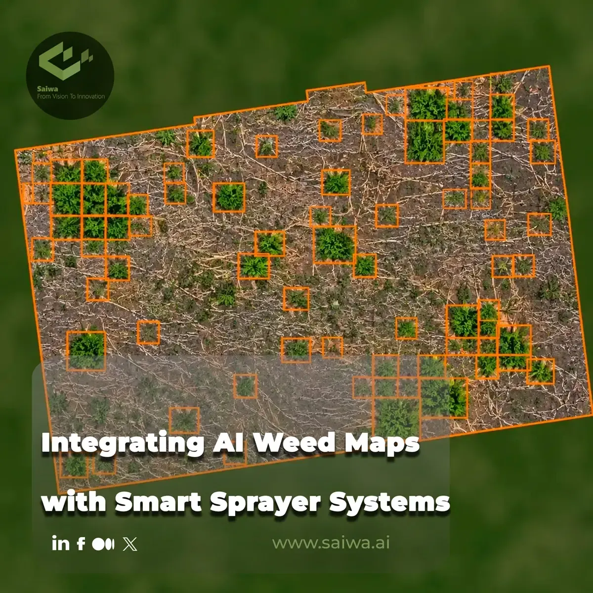
The output of an AI detection model typically takes the form of semantic segmentation or bounding box classification. In semantic segmentation, the algorithm classifies every individual pixel in the orthomosaic as either 'crop', 'weed', or 'background' (soil/shadows). This provides a highly granular, pixel-perfect map of weed infestations across the field.
Alternatively, bounding box classification draws localized grids around detected weed clusters. Regardless of the specific AI architecture, the objective is to attach highly accurate geographic coordinates (latitude and longitude) to the identified weed pressure. This spatial classification creates a digital ledger of exact locations requiring chemical intervention.
Detection Accuracy, Ground-Truth Validation, and Model Limitations
The viability of AI-driven weed mapping hinges on its precision and recall metrics. High detection accuracy ensures that weeds are successfully targeted (minimizing false negatives) while preventing the spraying of weed-free zones (minimizing false positives). However, AI models require rigorous ground-truth validation, where algorithmic outputs are checked against physical field scouting data to ensure reliability.
Despite advances, these models face operational limitations. Variable lighting conditions, shadows from cloud cover, and overlapping canopies (where weeds grow beneath the crop) can degrade detection accuracy. Furthermore, models trained in one geographical region or soil type may experience performance drops when deployed in unfamiliar environments, necessitating continuous retraining and localized model calibration.
Prescription Map Generation and Variable-Rate Zone Delineation
Converting Detection Outputs into Targeted Spraying Maps
The raw spatial data generated by AI models must be translated into machine-readable instructions. This process involves converting the segmented weed clusters into a prescription map (Rx map). The prescription map is a spatial database that divides the field into distinct management zones, assigning a specific application rate—often just 'on' or 'off'—to each geographic vector.
Software platforms take the high-resolution AI outputs and rasterize them into grids that align with the physical dimensions of the sprayer equipment. This conversion ensures that the digital map matches the mechanical capabilities of the tractor and sprayer implement that will execute the task.
Spray Zone, Buffer Zone, and No-Spray Region Logic
To account for GPS drift, wind-induced chemical drift, and mechanical latency, prescription maps incorporate buffer zones around detected weeds. When a weed is identified, the system designates a spray zone, but it also applies an additional buffer radius where the nozzles will activate slightly before and remain active slightly after passing the target.
Conversely, areas completely free of weed pressure are codified as explicit no-spray regions. This spatial logic ensures complete coverage of the biological target while maximizing chemical savings by strictly defining the boundaries of actuation.
Prescription Map Export and Integration with Farm Management Platforms
Once the prescription map is finalized, it must be exported in standard geospatial formats, such as Shapefile (.shp) or ISO XML, which are recognized by modern tractor terminals. Interoperability is critical; the map must seamlessly transfer from the processing software into the cab's Farm Management Information System (FMIS).
Integration via cloud-based API connections or physical USB transfer allows the tractor's onboard computer to ingest the map. Systems like the John Deere Operations Center can read these standardized files, linking the spatial coordinates of the prescription map with the tractor's real-time GPS navigation to prepare for actuation.
Smart Sprayer Hardware and Real-Time Actuation
Sensors, Control Systems, and Variable-Rate Nozzle Architecture
The physical execution of the AI weed map relies on advanced smart sprayer hardware. Modern sprayers are equipped with intelligent control systems that interpret the prescription map data in real-time. The core of this architecture is the variable-rate nozzle system, often utilizing Pulse Width Modulation (PWM) technology.
PWM valves can open and close at millisecond intervals, controlling the flow rate and droplet size independently of the tractor's ground speed. This localized control allows individual nozzles—or small sections of the sprayer boom—to actuate independently based on the underlying prescription map instructions.
GPS Positioning, Boom Control, and As-Applied Logging
Accurate actuation demands high-precision RTK (Real-Time Kinematic) GPS. As the tractor traverses the field, the onboard computer continuously compares the boom's exact geographic position against the prescription map. The system calculates the forward speed and boom dynamics, sending actuation signals to the specific nozzles passing over the designated spray zones.
Simultaneously, the smart sprayer logs exactly where and how much chemical was applied. This "as-applied" data is recorded in real-time, providing operators with a precise digital receipt of the operation. This logging is critical for verifying map execution, calculating chemical savings, and fulfilling regulatory compliance tracking.
Nozzle Control Strategies and Spatial Spray Execution
Executing the spray requires synchronized nozzle control strategies. Depending on the density of the weed patches, the system may employ spot spraying (individual nozzles firing over isolated weeds) or section control (larger boom sections activating over denser clusters).
The latency between the GPS reading, map processing, and valve actuation must be practically zero. Advanced systems predict the boom's trajectory and trigger the valves fractions of a second before the nozzle passes over the target, ensuring the spray fan fully intersects the weed canopy despite the forward motion of the machine.
Adoption Barriers, Standards Gaps, and Field Deployment Realities
Upfront Cost Constraints and Interoperability Challenges
Despite the proven efficiency of AI-driven targeted spraying, adoption faces significant hurdles, primarily driven by high initial capital expenditures. Retrofitting existing equipment with PWM nozzles, RTK GPS, and advanced terminals, or purchasing entirely new smart sprayers, requires a substantial upfront investment that can be difficult to amortize for smaller operations.
Furthermore, interoperability between different hardware and software brands remains a major friction point. Exporting maps from an independent drone software platform into proprietary tractor terminals often results in format compatibility issues. The lack of universal, open-source data standards forces operators into walled-garden ecosystems.
Connectivity Requirements and Data Management Overhead
Processing gigabytes of high-resolution drone imagery and transferring prescription maps requires robust digital infrastructure. Many rural farming regions lack the high-speed internet connectivity necessary to upload raw flight data to cloud-based AI processing servers.
Additionally, the data management overhead is substantial. Farm operators are forced to manage massive file sizes, ensure data backups, and navigate complex software interfaces. The technical expertise required to manage this pipeline from drone flight to tractor actuation represents a steep learning curve for traditional agricultural workforces.
Regulatory Pressure and Herbicide Resistance as Adoption Accelerators
Conversely, macroeconomic and biological pressures are accelerating the adoption of these systems. As weed populations develop resistance to standard active ingredients (like glyphosate), operators are forced to use more expensive, specialized chemicals. The high cost of these alternative chemicals makes broadcast spraying economically unviable, pushing operators toward targeted application technologies.
Simultaneously, environmental agencies are heavily restricting chemical usage near waterways and limiting the total active ingredient applied per hectare per year. Smart sprayer systems provide the exact documentation (via as-applied maps) and the drastic chemical reductions necessary to operate profitably within these tightening regulatory frameworks.
References (6)
Comments
Be the first to share your thoughts
No comments yet
Start the conversation by sharing your thoughts
Table of Contents
No headings were found on this page.